IMAGES TAKEN NEAR TO
Low Borland Way, GLASGOW, G76 0BP
Introduction
This page details the photographs taken nearby to Low Borland Way, G76 0BP by members of the Geograph project.
The Geograph project started in 2005 with the aim of publishing, organising and preserving representative images for every square kilometre of Great Britain, Ireland and the Isle of Man.

There are currently over 7.5m images from over14,400 individuals and you can help contribute to the project by visiting https://www.geograph.org.uk
Image Map
Images are licensed for reuse under creativecommons.org/licenses/by-sa/2.0
Notes
- Clicking on the map will re-center to the selected point.
- The higher the marker number, the further away the image location is from the centre of the postcode.
Image Listing (6 Images Found)
Images are licensed for reuse under creativecommons.org/licenses/by-sa/2.0
Image
Details
Distance
2
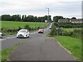
B767 north of Eaglesham
A bike path avoids the roundabout on the A736 but dumps you on a tricky road crossing if heading north. Traffic leaving the dual carriageway is on you very quickly.
Image: © Richard Webb
Taken: 17 Aug 2022
0.15 miles
3
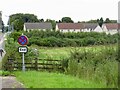
Waterfoot Village
From Cartside Road.
Image: © Stephen Sweeney
Taken: 17 Nov 2009
0.22 miles
4
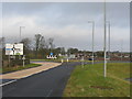
Belle Craig Roundabout
The intersection of the A726, East Kilbride to Kimarnock road, and the B767, Eaglesham to Busby road, from which the photograph is taken.
Image: © G Laird
Taken: 3 Jan 2013
0.24 miles

