IMAGES TAKEN NEAR TO
Polnoon Street, GLASGOW, G76 0BB
Introduction
This page details the photographs taken nearby to Polnoon Street, G76 0BB by members of the Geograph project.
The Geograph project started in 2005 with the aim of publishing, organising and preserving representative images for every square kilometre of Great Britain, Ireland and the Isle of Man.

There are currently over 7.5m images from over14,400 individuals and you can help contribute to the project by visiting https://www.geograph.org.uk
Image Map
Images are licensed for reuse under creativecommons.org/licenses/by-sa/2.0
Notes
- Clicking on the map will re-center to the selected point.
- The higher the marker number, the further away the image location is from the centre of the postcode.
Image Listing (124 Images Found)
Images are licensed for reuse under creativecommons.org/licenses/by-sa/2.0
Image
Details
Distance
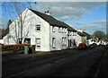
3
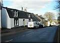
Coney Craig
A house on Polnoon Street built for Jas Fulton, weaver about 1796 and extended in 1863. It is Category C listed http://portal.historicenvironment.scot/designation/LB5221
Image: © Richard Sutcliffe
Taken: 7 Mar 2022
0.01 miles
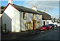
4
Bankhead
House set back off Polnoon Street in Eaglesham.
Image: © Richard Sutcliffe
Taken: 7 Mar 2022
0.02 miles
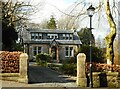
5
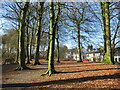
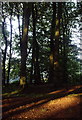
The Orry, Eaglesham
Woodland in The Orry, the public park that lies in the middle of the planned village of Eaglesham. Its alternative name is The Aurrie:
'“The Aurrie,” in Eaglesham, Renfrewshire, the name given to a rectangular open space, planted with trees, used by the villagers as a public park; in the original charter by which it was set apart for public use, it was called the “Area” situated between certain boundaries; hence the name, “The Aurrie.”'
https://dsl.ac.uk/entry/snd/aurea
Image: © Alan O'Dowd
Taken: 24 Feb 2023
0.03 miles
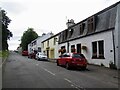
8
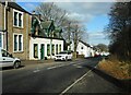
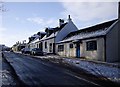
Polnoon Street, Eaglesham
Houses down the left hand side, with 'The Orry' on the right. The Orry is the local name for the green, comprising grassland and woodland, which separates the village's two main streets, Polnoon Street (originally called North Street); and Montgomery Street (originally called South Street). Eaglesham is a planned village and was laid out in an 'A' shape in the late 1700s by Alexander, Tenth Earl of Eglinton, with Mid Road forming the cross member of the letter. The 'A' reflects the initial of the Earl's Christian name.
Image: © Richard Sutcliffe
Taken: 7 Mar 2022
0.04 miles
9
The Orry
A Summer's day in the Orry near Linn Cottage. Click on these links to discover about the Orry http://www.geograph.org.uk/photo/1477760 and to see other views http://www.geograph.org.uk/photo/1424832 .
Image: © Kenneth Mallard
Taken: 17 Jul 2007
0.04 miles
10
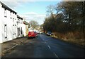
Polnoon Street
Polnoon Street looking towards Townhead. The single-storey cottage on the right http://www.geograph.org.uk/photo/1657830 was renovated in 1904 in an art-nouveau manner.
Image: © Kenneth Mallard
Taken: 10 Jan 2010
0.04 miles