IMAGES TAKEN NEAR TO
Machrie Green, GLASGOW, G75 9NJ
Introduction
This page details the photographs taken nearby to Machrie Green, G75 9NJ by members of the Geograph project.
The Geograph project started in 2005 with the aim of publishing, organising and preserving representative images for every square kilometre of Great Britain, Ireland and the Isle of Man.

There are currently over 7.5m images from over14,400 individuals and you can help contribute to the project by visiting https://www.geograph.org.uk
Image Map
Images are licensed for reuse under creativecommons.org/licenses/by-sa/2.0
Notes
- Clicking on the map will re-center to the selected point.
- The higher the marker number, the further away the image location is from the centre of the postcode.
Image Listing (11 Images Found)
Images are licensed for reuse under creativecommons.org/licenses/by-sa/2.0
Image
Details
Distance
2
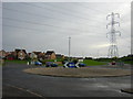
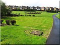
Silage field, South Shields
A recently harvested field.
Image: © Richard Webb
Taken: 4 Jun 2012
0.14 miles
3
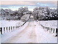
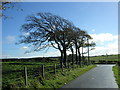
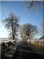
Snow Covered Minor Road Near East Kilbride
Image: © Iain Thompson
Taken: 24 Dec 2009
0.16 miles
4
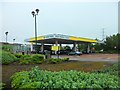
Morrisons petrol station, Lindsayfield, East Kilbride
Image: © Stephen Sweeney
Taken: 5 Jul 2012
0.16 miles
9
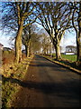
Shields Road on a Frosty Morning
Shield Road forms the southern edge of Lindsayfield
Image: © Iain Thompson
Taken: 30 Nov 2008
0.24 miles
10
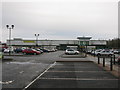
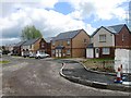
Morrisons Supermarket, Greenhills, East Kilbride
Supermarket just off Greenhills Road in the southern outskirts of East Kilbride.
Image: © G Laird
Taken: 26 Nov 2012
0.24 miles