IMAGES TAKEN NEAR TO
Broom Crescent, GLASGOW, G75 9JE
Introduction
This page details the photographs taken nearby to Broom Crescent, G75 9JE by members of the Geograph project.
The Geograph project started in 2005 with the aim of publishing, organising and preserving representative images for every square kilometre of Great Britain, Ireland and the Isle of Man.

There are currently over 7.5m images from over14,400 individuals and you can help contribute to the project by visiting https://www.geograph.org.uk
Image Map
Images are licensed for reuse under creativecommons.org/licenses/by-sa/2.0
Notes
- Clicking on the map will re-center to the selected point.
- The higher the marker number, the further away the image location is from the centre of the postcode.
Image Listing (8 Images Found)
Images are licensed for reuse under creativecommons.org/licenses/by-sa/2.0
Image
Details
Distance
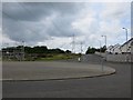
1
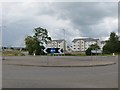
Roundabout, Auldhouse Road
There has been some recent expansion of East Kilbride here.
Image: © Richard Webb
Taken: 1 Aug 2014
0.13 miles
2
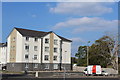
Catacol Grove, East Kilbride
New housing development
Image: © Leslie Barrie
Taken: 10 Sep 2014
0.18 miles
3
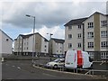
Catacol Grove
New residential street on the southern edge of East Kilbride.
Image: © Richard Webb
Taken: 1 Aug 2014
0.19 miles
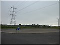
4
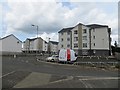
New houses off Auldhouse Road
View from one of the roundabouts to a newly built residential street on the southern edge of East Kilbride, south of Greenhills.
Greenhills and Whitehills were farms before the new town.
Image: © Richard Webb
Taken: 1 Aug 2014
0.19 miles
5
Lindsayfield Avenue
A newish road built as East Kilbride extends southwards.
Image: © Richard Webb
Taken: 1 Aug 2014
0.21 miles
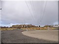
6
Roundabout on Auldhouse Road
At Lindsayfield Avenue.
Image: © Stephen Sweeney
Taken: 5 Jul 2012
0.22 miles
8
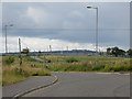
Auldhouse Road
View southwards from a new roundabout on what is the current southern edge of East Kilbride.
Image: © Richard Webb
Taken: 1 Aug 2014
0.23 miles