IMAGES TAKEN NEAR TO
Larch Drive, GLASGOW, G75 9HE
Introduction
This page details the photographs taken nearby to Larch Drive, G75 9HE by members of the Geograph project.
The Geograph project started in 2005 with the aim of publishing, organising and preserving representative images for every square kilometre of Great Britain, Ireland and the Isle of Man.

There are currently over 7.5m images from over14,400 individuals and you can help contribute to the project by visiting https://www.geograph.org.uk
Image Map
Images are licensed for reuse under creativecommons.org/licenses/by-sa/2.0
Notes
- Clicking on the map will re-center to the selected point.
- The higher the marker number, the further away the image location is from the centre of the postcode.
Image Listing (9 Images Found)
Images are licensed for reuse under creativecommons.org/licenses/by-sa/2.0
Image
Details
Distance
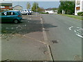
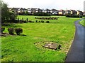
1
Pine Crescent, Greenhills, East Kilbride
Image: © Stephen Sweeney
Taken: 5 Jul 2012
0.15 miles
2
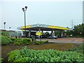
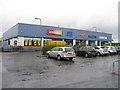
Morrisons petrol station, Lindsayfield, East Kilbride
Image: © Stephen Sweeney
Taken: 5 Jul 2012
0.18 miles
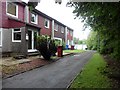
4
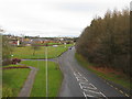
Stroud Road, Greenhills, East Kilbride
Viewed from a footbridge over Stroud Road.
Image: © G Laird
Taken: 26 Nov 2012
0.22 miles
5
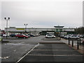
Morrisons Supermarket, Greenhills, East Kilbride
Supermarket just off Greenhills Road in the southern outskirts of East Kilbride.
Image: © G Laird
Taken: 26 Nov 2012
0.22 miles
6
Castlefield Primary School
East Kilbride.
Image: © Richard Webb
Taken: 1 Aug 2014
0.23 miles
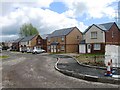
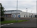
8
Shops, Greenhills, East Kilbride
On Lickprivick Road, near the junction with Greenhills Road.
Image: © G Laird
Taken: 2 Oct 2012
0.25 miles