IMAGES TAKEN NEAR TO
Liddell Grove, GLASGOW, G75 9AD
Introduction
This page details the photographs taken nearby to Liddell Grove, G75 9AD by members of the Geograph project.
The Geograph project started in 2005 with the aim of publishing, organising and preserving representative images for every square kilometre of Great Britain, Ireland and the Isle of Man.

There are currently over 7.5m images from over14,400 individuals and you can help contribute to the project by visiting https://www.geograph.org.uk
Image Map
Images are licensed for reuse under creativecommons.org/licenses/by-sa/2.0
Notes
- Clicking on the map will re-center to the selected point.
- The higher the marker number, the further away the image location is from the centre of the postcode.
Image Listing (6 Images Found)
Images are licensed for reuse under creativecommons.org/licenses/by-sa/2.0
Image
Details
Distance
1
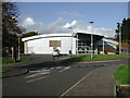
The Murray Owen Centre
Purpose built day centre / community centre supporting people with Learning difficulties. Also contains community hall, coffee bar, public internet area etc.
Image: © Paul Nardone
Taken: 9 Oct 2006
0.03 miles
2
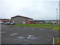
Heathery Knowe Primary School
In East Kilbride.
Image: © Stephen Sweeney
Taken: 5 Jul 2012
0.14 miles

4

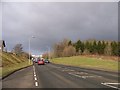
Whitehills Terrace
Passing Heathery Knowe and St Louise primary schools, this was once the road between pre new town East Kilbride and Auldhouse. It is no longer a through route for motorised vehicles, but a rare easy cycling route out of East Kilbride.
Image: © Richard Webb
Taken: 1 Aug 2014
0.19 miles
5
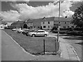
Baird Hill
Residential street, East Kilbride.
Image: © Richard Webb
Taken: 4 Jun 2012
0.19 miles
6
Stroud Road, Greenhills, East Kilbride
Image: © Elliott Simpson
Taken: 23 Apr 2013
0.22 miles