IMAGES TAKEN NEAR TO
Borthwick Drive, GLASGOW, G75 8YH
Introduction
This page details the photographs taken nearby to Borthwick Drive, G75 8YH by members of the Geograph project.
The Geograph project started in 2005 with the aim of publishing, organising and preserving representative images for every square kilometre of Great Britain, Ireland and the Isle of Man.

There are currently over 7.5m images from over14,400 individuals and you can help contribute to the project by visiting https://www.geograph.org.uk
Image Map
Images are licensed for reuse under creativecommons.org/licenses/by-sa/2.0
Notes
- Clicking on the map will re-center to the selected point.
- The higher the marker number, the further away the image location is from the centre of the postcode.
Image Listing (7 Images Found)
Images are licensed for reuse under creativecommons.org/licenses/by-sa/2.0
Image
Details
Distance
2
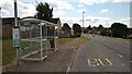
Bus stop on Greenhills Road, East Kilbride
Image: © Gordon Brown
Taken: 2 Aug 2021
0.14 miles
3
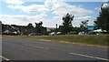
"New Menu Coming Soon" says one of the many signs
Off Greenhills Road.
Image: © Gordon Brown
Taken: 2 Aug 2021
0.14 miles
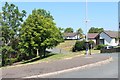
4

Cottage on Eaglesham Road
Just east of the police college, on the edge of East Kilbride.
Image: © Stephen Sweeney
Taken: 17 Jan 2012
0.18 miles
5

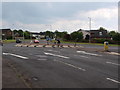
Looking on to one of East Kilbride's many roundabouts
Image: © Gordon Brown
Taken: 2 Aug 2021
0.20 miles
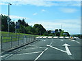
7
Roundabout at Peel Park
The picture shows the roundabout on Eaglesham Road from Redwood Drive. Originally an area of modern offices and industrial units, known as Peel Park, this edge of East Kilbride now includes more and more recent housing developments.
Image: © Alec MacKinnon
Taken: 9 Jun 2018
0.25 miles