IMAGES TAKEN NEAR TO
Coniston, GLASGOW, G75 8JR
Introduction
This page details the photographs taken nearby to Coniston, G75 8JR by members of the Geograph project.
The Geograph project started in 2005 with the aim of publishing, organising and preserving representative images for every square kilometre of Great Britain, Ireland and the Isle of Man.

There are currently over 7.5m images from over14,400 individuals and you can help contribute to the project by visiting https://www.geograph.org.uk
Image Map (Loading...)


Getting Data...Please wait
Leaflet Map data © OpenStreetMap
Images are licensed for reuse under creativecommons.org/licenses/by-sa/2.0
Notes
- Clicking on the map will re-center to the selected point.
- The higher the marker number, the further away the image location is from the centre of the postcode.
Image Listing (8 Images Found)
Images are licensed for reuse under creativecommons.org/licenses/by-sa/2.0
Image
Details
Distance
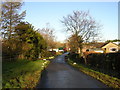
1
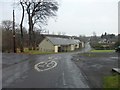
Newlands, East Kilbride
At the southwest of the town.
Image: © Stephen Sweeney
Taken: 17 Jan 2012
0.05 miles
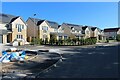
4
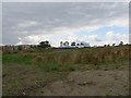
Building site, Newlands
Building on fields on the edge of East Kilbride.
Image: © Richard Webb
Taken: 1 Aug 2014
0.20 miles
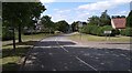
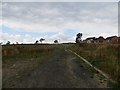
5
Newlands, East Kilbride
The approach to East Kilbride near Newlands Farm. Part of a signposted cycle route network but beware of hawthorn hedge trimmings.
Image: © Iain Thompson
Taken: 24 Dec 2005
0.20 miles
6
Newlands, East Kilbride
Land being developed for housing.
Image: © Richard Webb
Taken: 1 Aug 2014
0.20 miles
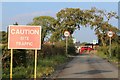
8
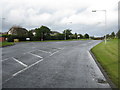
Greenhills Road
At the junction with the minor road Swift Place.
Image: © G Laird
Taken: 2 Oct 2012
0.23 miles