IMAGES TAKEN NEAR TO
Wakefield Avenue, GLASGOW, G75 8HG
Introduction
This page details the photographs taken nearby to Wakefield Avenue, G75 8HG by members of the Geograph project.
The Geograph project started in 2005 with the aim of publishing, organising and preserving representative images for every square kilometre of Great Britain, Ireland and the Isle of Man.

There are currently over 7.5m images from over14,400 individuals and you can help contribute to the project by visiting https://www.geograph.org.uk
Image Map
Images are licensed for reuse under creativecommons.org/licenses/by-sa/2.0
Notes
- Clicking on the map will re-center to the selected point.
- The higher the marker number, the further away the image location is from the centre of the postcode.
Image Listing (16 Images Found)
Images are licensed for reuse under creativecommons.org/licenses/by-sa/2.0
Image
Details
Distance

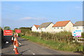
2
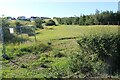
Awaiting development
House building is taking place nearby and the roads are in place for a development here. This is the same place in 2005:Image
Image: © Richard Webb
Taken: 1 Aug 2014
0.08 miles

4
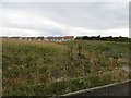
House building, East Kilbride
Former fields, now a building site.
Image: © Richard Webb
Taken: 1 Aug 2014
0.11 miles
5
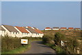
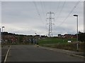
New housing by Jackton Road, East Kilbride
Image: © Leslie Barrie
Taken: 10 Sep 2014
0.11 miles
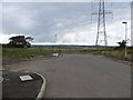
8
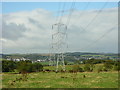
New houses, East Kilbride
A power line runs through new houses and building sites off Lindsayfield Road.
Image: © Richard Webb
Taken: 1 Aug 2014
0.15 miles
9
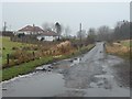
Approaching Dunrobin on Newlands Road
Image: © Stephen Sweeney
Taken: 17 Jan 2012
0.17 miles