IMAGES TAKEN NEAR TO
Le Froy Gardens, GLASGOW, G75 8BL
Introduction
This page details the photographs taken nearby to Le Froy Gardens, G75 8BL by members of the Geograph project.
The Geograph project started in 2005 with the aim of publishing, organising and preserving representative images for every square kilometre of Great Britain, Ireland and the Isle of Man.

There are currently over 7.5m images from over14,400 individuals and you can help contribute to the project by visiting https://www.geograph.org.uk
Image Map
Images are licensed for reuse under creativecommons.org/licenses/by-sa/2.0
Notes
- Clicking on the map will re-center to the selected point.
- The higher the marker number, the further away the image location is from the centre of the postcode.
Image Listing (14 Images Found)
Images are licensed for reuse under creativecommons.org/licenses/by-sa/2.0
Image
Details
Distance
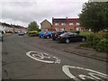
2
Alberta Avenue
Residential area, East Kilbride.
Image: © Richard Webb
Taken: 1 Aug 2014
0.18 miles
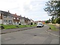
3
Melbourne Avenue, East Kilbride
Between The Murray and Westwood.
Image: © Stephen Sweeney
Taken: 26 Jan 2010
0.18 miles
4
Alberta Avenue, East Kilbride
The land on the right was formerly the site of Duncanrig Secondary School. Now it is occupied by a recent development of private housing.
Image: © G Laird
Taken: 2 Oct 2012
0.18 miles
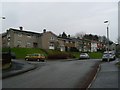
5
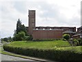
Our Lady of Lourdes Church, East Kilbride
World War II airfield style tower on Westwood Road
Image: © Richard Webb
Taken: 1 Aug 2014
0.19 miles
6
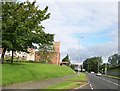
Catholic Church on The Murray Road, East Kilbride
Image: © Elliott Simpson
Taken: 5 Aug 2011
0.19 miles
7
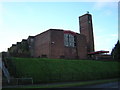
Our Lady of Lourdes Church, East Kilbride
Image: © Iain Thompson
Taken: 4 Dec 2005
0.20 miles
8
East Milton Primary School
A new building in East Kilbride.
Image: © Richard Webb
Taken: 1 Aug 2014
0.20 miles
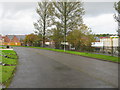
9
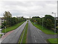
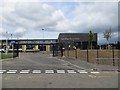
The Queensway (A726), East Kilbride
Looking along the A726 from a footbridge in the direction of East Kilbride town centre.
Image: © G Laird
Taken: 2 Oct 2012
0.23 miles
10
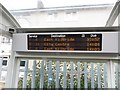
Bus stop, Westwood Road
Destination board and No campaign sticker in a bus shelter. The bus stop was useful as it allowed me to get off the pavement and back on the road again - the fencing is ferocious here.
Image: © Richard Webb
Taken: 1 Aug 2014
0.23 miles