IMAGES TAKEN NEAR TO
Ardcrags Terrace, G75 7AN
Introduction
This page details the photographs taken nearby to Ardcrags Terrace, G75 7AN by members of the Geograph project.
The Geograph project started in 2005 with the aim of publishing, organising and preserving representative images for every square kilometre of Great Britain, Ireland and the Isle of Man.

There are currently over 7.5m images from over14,400 individuals and you can help contribute to the project by visiting https://www.geograph.org.uk
Image Map
Images are licensed for reuse under creativecommons.org/licenses/by-sa/2.0
Notes
- Clicking on the map will re-center to the selected point.
- The higher the marker number, the further away the image location is from the centre of the postcode.
Image Listing (15 Images Found)
Images are licensed for reuse under creativecommons.org/licenses/by-sa/2.0
Image
Details
Distance
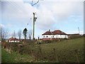
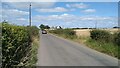
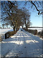
2
Approaching Dunrobin on Newlands Road
Image: © Stephen Sweeney
Taken: 17 Jan 2012
0.12 miles
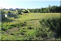
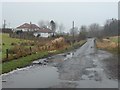
8
Newlands, East Kilbride
The approach to East Kilbride near Newlands Farm. Part of a signposted cycle route network but beware of hawthorn hedge trimmings.
Image: © Iain Thompson
Taken: 24 Dec 2005
0.20 miles
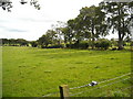
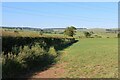
10
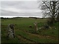
Farmland near Jackton
The fields are just east of the farm called Newhouse. Old stone gateposts like these are commonly seen in this part of the country.
Image: © Alec MacKinnon
Taken: 1 Apr 2021
0.20 miles