IMAGES TAKEN NEAR TO
Hurlawcrook Court, GLASGOW, G75 0ZW
Introduction
This page details the photographs taken nearby to Hurlawcrook Court, G75 0ZW by members of the Geograph project.
The Geograph project started in 2005 with the aim of publishing, organising and preserving representative images for every square kilometre of Great Britain, Ireland and the Isle of Man.

There are currently over 7.5m images from over14,400 individuals and you can help contribute to the project by visiting https://www.geograph.org.uk
Image Map
Images are licensed for reuse under creativecommons.org/licenses/by-sa/2.0
Notes
- Clicking on the map will re-center to the selected point.
- The higher the marker number, the further away the image location is from the centre of the postcode.
Image Listing (7 Images Found)
Images are licensed for reuse under creativecommons.org/licenses/by-sa/2.0
Image
Details
Distance
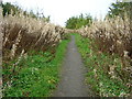
1
Footpath Near Calder Water
The water running down the path seemed to be coming from a leaking main
Image: © Iain Thompson
Taken: 10 Aug 2008
0.07 miles
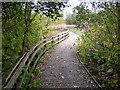
2
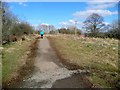
Path between Langlands Moss Nature Reserve and Calderglen Country Park
Image: © Gordon Brown
Taken: 3 Apr 2013
0.10 miles
3
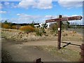
Entrance to Langland Moss Nature Reserve, East Kilbride
Factories in the Kelvin Industrial Area in the background.
Image: © Gordon Brown
Taken: 3 Apr 2013
0.11 miles
4
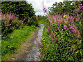
Path from Calder Water
Path from Calder Water to Langlands Road with dead fireweed on either side
Image: © Iain Thompson
Taken: 29 Oct 2006
0.13 miles
5
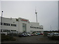
Sainsbury Wind Turbine, East Kilbride
Sainsbury Distribution Centre and Wind Turbine, Langlands Industrial Estate, East Kilbride
Image: © Iain Thompson
Taken: 29 Sep 2005
0.16 miles
7
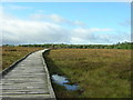
Langland Nature Reserve, East Kilbride
A raised bog.
Image: © Iain Thompson
Taken: 1 Oct 2005
0.24 miles