IMAGES TAKEN NEAR TO
Hurlawcrook Drive, GLASGOW, G75 0ZU
Introduction
This page details the photographs taken nearby to Hurlawcrook Drive, G75 0ZU by members of the Geograph project.
The Geograph project started in 2005 with the aim of publishing, organising and preserving representative images for every square kilometre of Great Britain, Ireland and the Isle of Man.

There are currently over 7.5m images from over14,400 individuals and you can help contribute to the project by visiting https://www.geograph.org.uk
Image Map (Loading...)


Getting Data...Please wait
Leaflet Map data © OpenStreetMap
Images are licensed for reuse under creativecommons.org/licenses/by-sa/2.0
Notes
- Clicking on the map will re-center to the selected point.
- The higher the marker number, the further away the image location is from the centre of the postcode.
Image Listing (14 Images Found)
Images are licensed for reuse under creativecommons.org/licenses/by-sa/2.0
Image
Details
Distance
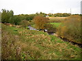
3
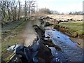
Path beside the Calder Water
The burn lies off to the right.
Image: © Gordon Brown
Taken: 3 Apr 2013
0.09 miles
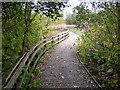
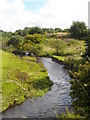
4
Erosion by the Calder Water
The old path is rapidly going, with the new replacement path to the left.
Image: © Gordon Brown
Taken: 3 Apr 2013
0.11 miles
5
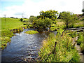
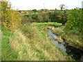
Calder Water
The wet summer is responsible for the high water levels
Image: © Iain Thompson
Taken: 10 Aug 2008
0.11 miles
6
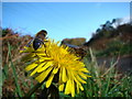
Two Eristalis hoverflies on a dandelion
Image: © Dannie Calder
Taken: 16 Oct 2007
0.11 miles
9
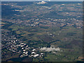
East Kilbride and Hamilton from the air
Strathclyde Loch and Motherwell are visible in the distance.
Image: © Thomas Nugent
Taken: 19 Jul 2015
0.14 miles