IMAGES TAKEN NEAR TO
The Boardwalk, GLASGOW, G75 0YW
Introduction
This page details the photographs taken nearby to The Boardwalk, G75 0YW by members of the Geograph project.
The Geograph project started in 2005 with the aim of publishing, organising and preserving representative images for every square kilometre of Great Britain, Ireland and the Isle of Man.

There are currently over 7.5m images from over14,400 individuals and you can help contribute to the project by visiting https://www.geograph.org.uk
Image Map
Images are licensed for reuse under creativecommons.org/licenses/by-sa/2.0
Notes
- Clicking on the map will re-center to the selected point.
- The higher the marker number, the further away the image location is from the centre of the postcode.
Image Listing (4 Images Found)
Images are licensed for reuse under creativecommons.org/licenses/by-sa/2.0
Image
Details
Distance
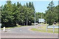
1

Roundabout on Stroud Road, East Kilbride
Di Maggio's Restaurant on the other side of the roundabout.
Image: © G Laird
Taken: 26 Nov 2012
0.09 miles
3
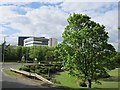
Park in High Common Road
A park in the middle of a split level road junction. It is accessible by path. A slip connects High Common Road with Strathaven Road. The junction dates back to the early days of East Kilbride New Town.
Image: © Richard Webb
Taken: 4 Jun 2012
0.23 miles
4

Scottish Western Zone Regional War Room
A cold-war era defensive and administrative bunker, now disused and within the grounds of the Technology Park. It consists of a concrete blockhouse with an entrance on the two long faces and three ventilation towers on the roof.
http://www.subbrit.org.uk/rsg/sites/e/east_kilbride/index.html
Image: © Alan O'Dowd
Taken: 30 Jan 2015
0.23 miles