IMAGES TAKEN NEAR TO
Glenfield Road, GLASGOW, G75 0RA
Introduction
This page details the photographs taken nearby to Glenfield Road, G75 0RA by members of the Geograph project.
The Geograph project started in 2005 with the aim of publishing, organising and preserving representative images for every square kilometre of Great Britain, Ireland and the Isle of Man.

There are currently over 7.5m images from over14,400 individuals and you can help contribute to the project by visiting https://www.geograph.org.uk
Image Map
Images are licensed for reuse under creativecommons.org/licenses/by-sa/2.0
Notes
- Clicking on the map will re-center to the selected point.
- The higher the marker number, the further away the image location is from the centre of the postcode.
Image Listing (4 Images Found)
Images are licensed for reuse under creativecommons.org/licenses/by-sa/2.0
Image
Details
Distance
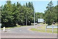
1

Roundabout on Stroud Road, East Kilbride
Di Maggio's Restaurant on the other side of the roundabout.
Image: © G Laird
Taken: 26 Nov 2012
0.09 miles
2

Kelvin Industrial Estate
Looking across the A726 from the New Farm Carvery, a popular place for a pub lunch
Image: © M J Richardson
Taken: 6 Apr 2009
0.09 miles
4
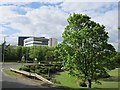
Park in High Common Road
A park in the middle of a split level road junction. It is accessible by path. A slip connects High Common Road with Strathaven Road. The junction dates back to the early days of East Kilbride New Town.
Image: © Richard Webb
Taken: 4 Jun 2012
0.20 miles