IMAGES TAKEN NEAR TO
East Kilbride, GLASGOW, G75 0QJ
Introduction
This page details the photographs taken nearby to G75 0QJ by members of the Geograph project.
The Geograph project started in 2005 with the aim of publishing, organising and preserving representative images for every square kilometre of Great Britain, Ireland and the Isle of Man.

There are currently over 7.5m images from over14,400 individuals and you can help contribute to the project by visiting https://www.geograph.org.uk
Image Map
Images are licensed for reuse under creativecommons.org/licenses/by-sa/2.0
Notes
- Clicking on the map will re-center to the selected point.
- The higher the marker number, the further away the image location is from the centre of the postcode.
Image Listing (16 Images Found)
Images are licensed for reuse under creativecommons.org/licenses/by-sa/2.0
Image
Details
Distance
1
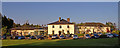
Crutherland House Hotel
Evening sun highlights the hotel.
Image: © wfmillar
Taken: 23 May 2010
0.04 miles
2
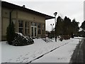
Crutherland House Hotel
Covered by an unusually late spring snow flurry.
Image: © Stephen Sweeney
Taken: 23 Mar 2013
0.07 miles
3
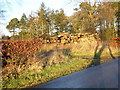
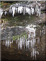
Log Pile
Large and old log pile near East Flatt
Image: © Iain Thompson
Taken: 24 Dec 2005
0.11 miles
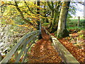
4
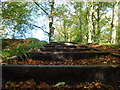
Stairs on footpath in Calderglen Country Park
Image: © Dannie Calder
Taken: 16 Oct 2007
0.14 miles
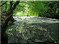
7
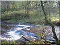
Calder Water in Calderglen Country Park
Image: © Dannie Calder
Taken: 30 Oct 2004
0.16 miles
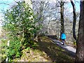
8
Calderglen Country Park, East Kilbride
Image: © Dannie Calder
Taken: 16 Oct 2007
0.16 miles
9
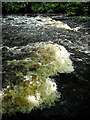
Path above Flatt Linn
Flatt Linn is a waterfall on the Calder Water, down to the right.
Image: © Gordon Brown
Taken: 3 Apr 2013
0.17 miles