IMAGES TAKEN NEAR TO
Macadam Place, GLASGOW, G75 0JR
Introduction
This page details the photographs taken nearby to Macadam Place, G75 0JR by members of the Geograph project.
The Geograph project started in 2005 with the aim of publishing, organising and preserving representative images for every square kilometre of Great Britain, Ireland and the Isle of Man.

There are currently over 7.5m images from over14,400 individuals and you can help contribute to the project by visiting https://www.geograph.org.uk
Image Map
Images are licensed for reuse under creativecommons.org/licenses/by-sa/2.0
Notes
- Clicking on the map will re-center to the selected point.
- The higher the marker number, the further away the image location is from the centre of the postcode.
Image Listing (9 Images Found)
Images are licensed for reuse under creativecommons.org/licenses/by-sa/2.0
Image
Details
Distance
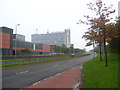
1
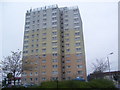
Dunlop Tower
A tower block on Telford Road.
Image: © Ross Watson
Taken: 10 Sep 2012
0.11 miles
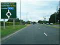
2
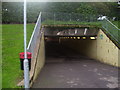
Pedestrian Tunnel
A tunnel leading into East Kilbride Shopping Centre.
Image: © Ross Watson
Taken: 10 Sep 2012
0.18 miles
3
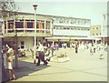
East Kilbride Town Centre
"The Mushroom" on the plaza at the shopping precinct in the heart of East Kilbride New Town.
Image: © Colin Smith
Taken: Unknown
0.20 miles
4
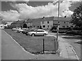
Baird Hill
Residential street, East Kilbride.
Image: © Richard Webb
Taken: 4 Jun 2012
0.21 miles
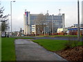
5
Plaza Tower and Shopping Mall
The tower and centre on Queensway (A726).
Image: © Ross Watson
Taken: 10 Sep 2012
0.21 miles
7
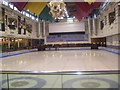
East Kilbride Ice Rink
The ice rink in East Kilbride Shopping Centre.
Image: © Ross Watson
Taken: 10 Sep 2012
0.23 miles
9
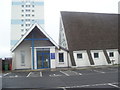
St Mark's Scottish Episcopal Church
The Church on Telford Road, with Lister Tower in the background.
Image: © Ross Watson
Taken: 10 Sep 2012
0.25 miles