IMAGES TAKEN NEAR TO
Westgarth Place, GLASGOW, G74 5NT
Introduction
This page details the photographs taken nearby to Westgarth Place, G74 5NT by members of the Geograph project.
The Geograph project started in 2005 with the aim of publishing, organising and preserving representative images for every square kilometre of Great Britain, Ireland and the Isle of Man.

There are currently over 7.5m images from over14,400 individuals and you can help contribute to the project by visiting https://www.geograph.org.uk
Image Map
Images are licensed for reuse under creativecommons.org/licenses/by-sa/2.0
Notes
- Clicking on the map will re-center to the selected point.
- The higher the marker number, the further away the image location is from the centre of the postcode.
Image Listing (6 Images Found)
Images are licensed for reuse under creativecommons.org/licenses/by-sa/2.0
Image
Details
Distance
1

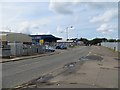
Industrial units, College Milton
An industrial estate in East Kilbride. At the time of visit there was a high quality catering van operating here. I hope to return!
Image: © Richard Webb
Taken: 1 Aug 2014
0.08 miles
2

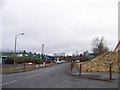
Glenburn Way, College Milton
Once this was the rural A726, now a distribution road for an industrial estate.
Image: © Richard Webb
Taken: 1 Aug 2014
0.12 miles
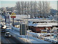
3

Burn Stewart Distillers
On Glenburn Way, East Kilbride.
Image: © Richard Webb
Taken: 1 Aug 2014
0.13 miles
4
Glenburn Way
Once this was the rural A726, now a distribution road for an industrial estate.
Image: © Richard Webb
Taken: 1 Aug 2014
0.17 miles