IMAGES TAKEN NEAR TO
William Grange, GLASGOW, G74 5DF
Introduction
This page details the photographs taken nearby to William Grange, G74 5DF by members of the Geograph project.
The Geograph project started in 2005 with the aim of publishing, organising and preserving representative images for every square kilometre of Great Britain, Ireland and the Isle of Man.

There are currently over 7.5m images from over14,400 individuals and you can help contribute to the project by visiting https://www.geograph.org.uk
Image Map
Images are licensed for reuse under creativecommons.org/licenses/by-sa/2.0
Notes
- Clicking on the map will re-center to the selected point.
- The higher the marker number, the further away the image location is from the centre of the postcode.
Image Listing (8 Images Found)
Images are licensed for reuse under creativecommons.org/licenses/by-sa/2.0
Image
Details
Distance
1
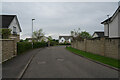
Baroness Drive
Baroness Drive leads to other short drives or streets but these are essentially a series of cul-de-sacs whose entrance is just behind the camera in this view.
Image: © Malcolm Neal
Taken: 7 May 2024
0.15 miles
2
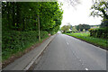
Peel Road
This is the road to Thorntonhall, which is an upmarket village with very desirable houses and some very expensive flats.
Image: © Malcolm Neal
Taken: 7 May 2024
0.16 miles
3
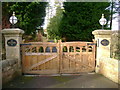
Bystone gates
Gated entrance to Bystone, a large house with gardens of impressive scale.
Image: © Mark Nightingale
Taken: 27 Jan 2010
0.18 miles
4
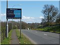
Welcome to South Lanarkshire
The sign is on East Kilbridge Road, about 250 metres beyond the last houses of Busby. The boundary between the council areas is shown on the map (the sign anticipates the boundary itself by about 100 metres).
Image: © Lairich Rig
Taken: 29 Apr 2005
0.22 miles
5
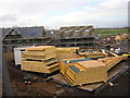
Thorntonhall Grows
New housing being built in Thorntonhall near East Kilbride
Image: © Iain Thompson
Taken: 5 Nov 2005
0.22 miles
6
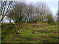
The remains of Busbyside Farm
Despite featuring on current Ordnance Survey mapping Busbyside Farm was clearly demolished a number of years ago.
Image: © Mark Nightingale
Taken: 27 Jan 2010
0.23 miles
7
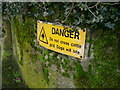
Security conscious
Residents of the exclusive village of Thorntonhall appear to be very security conscious given the disproportionate amount of high fencing and a large number of gates with numerical keypads. The first residence south of the A727 roundabout takes a less subtle approach.
Image: © Mark Nightingale
Taken: 27 Jan 2010
0.24 miles
8
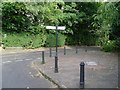
Fingerpost in Thorntonhall
At the corner of Peel Road and Braehead Road.
Image: © Stephen Sweeney
Taken: 16 Sep 2009
0.24 miles