IMAGES TAKEN NEAR TO
Howard Avenue, GLASGOW, G74 4ZA
Introduction
This page details the photographs taken nearby to Howard Avenue, G74 4ZA by members of the Geograph project.
The Geograph project started in 2005 with the aim of publishing, organising and preserving representative images for every square kilometre of Great Britain, Ireland and the Isle of Man.

There are currently over 7.5m images from over14,400 individuals and you can help contribute to the project by visiting https://www.geograph.org.uk
Image Map
Images are licensed for reuse under creativecommons.org/licenses/by-sa/2.0
Notes
- Clicking on the map will re-center to the selected point.
- The higher the marker number, the further away the image location is from the centre of the postcode.
Image Listing (11 Images Found)
Images are licensed for reuse under creativecommons.org/licenses/by-sa/2.0
Image
Details
Distance
1
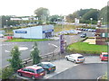
Car-centred East Kilbride
Area at Nerston catering for the motorist with drive-in access to motel, restaurant, pub and car phone warehouse.
Image: © Colin Smith
Taken: 28 Aug 2009
0.09 miles
2

Limekiln Ruin, East Kilbride
Recently rediscovered during construction of DIY warehouse.
Image: © Iain Thompson
Taken: 1 Oct 2005
0.09 miles
3

Mavor Avenue, East Kilbride
The houses are on the site of the old Rolls-Royce Aero-Engine Works which opened in 1953 and closed in 2019. The new streets Avon Drive and Dart Avenue are named after some of the engines associated with the works.
The Mavor and Coulson Mining Equipment works was on the left side of the road and was built around 1930. This site has also been re-developed with new housing. See, https://maps.nls.uk/geo/explore/#zoom=15.8&lat=55.77874&lon=-4.16692&layers=170&b=1
Image: © wrobison
Taken: 9 May 2023
0.09 miles
4
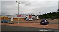
Nerston Industrial Estate
Home Store More, Carpet Right and Benson for Beds. B&Q is behind the photographer.
Image: © Gordon Brown
Taken: 12 Aug 2021
0.12 miles
5

The Lee Burn
Pub in East Kilbride, opposite the Kingsway Retail Park.
Image: © Stephen Sweeney
Taken: 17 Jan 2011
0.17 miles
6

Functional Agglomeration at Nerston
An area of garages, car sale and repair concerns in East Kilbride.
Image: © Colin Smith
Taken: 28 Aug 2009
0.19 miles
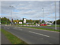
7

Roundabout at Nerston
Looking across the roundabout towards the Burger King Cafe on a bright but cold February afternoon.
Image: © Malcolm Neal
Taken: 2 Feb 2019
0.20 miles
8

Roundabout on the Glasgow Road
Retail parks on the northern edge of East Kilbride.
Image: © Richard Webb
Taken: 4 Jun 2012
0.21 miles
9
Roundabout at the entrance to the Kingsgate Retail Park, East Kilbride
Also looking along the A749 in the direction of Rutherglen.
Image: © G Laird
Taken: 16 Oct 2010
0.21 miles
10
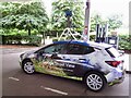
Streetview car
Filling up at Sainsbury's, Nerston
Image: © Richard Webb
Taken: 17 Aug 2022
0.24 miles