IMAGES TAKEN NEAR TO
Doonfoot Gardens, GLASGOW, G74 4XF
Introduction
This page details the photographs taken nearby to Doonfoot Gardens, G74 4XF by members of the Geograph project.
The Geograph project started in 2005 with the aim of publishing, organising and preserving representative images for every square kilometre of Great Britain, Ireland and the Isle of Man.

There are currently over 7.5m images from over14,400 individuals and you can help contribute to the project by visiting https://www.geograph.org.uk
Image Map
Images are licensed for reuse under creativecommons.org/licenses/by-sa/2.0
Notes
- Clicking on the map will re-center to the selected point.
- The higher the marker number, the further away the image location is from the centre of the postcode.
Image Listing (9 Images Found)
Images are licensed for reuse under creativecommons.org/licenses/by-sa/2.0
Image
Details
Distance
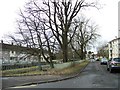
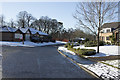
2
Lymekilns Road
A housing estate with large houses.
Image: © Richard Webb
Taken: 4 Jun 2012
0.17 miles
3
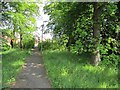
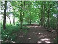
Woodland path
A path leading through woodland to Lymekilns Road from the busy West Mains Road.
Image: © Richard Webb
Taken: 4 Jun 2012
0.17 miles
4
Woodland beside the railway
This path takes a bit of finding and runs through a narrow strip of woodland beside the railway.
Image: © Richard Webb
Taken: 4 Jun 2012
0.17 miles
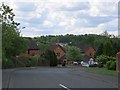
5
Bumble Bee Nursery
A small nursery in a modern housing estate almost at the end of a cul-de-sac.
Image: © Malcolm Neal
Taken: 2 Feb 2019
0.18 miles
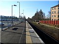
6
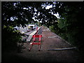
End of the platform
End of the platform and rail line to Glasgow from East Kilbride. 4th August 2009 12.00pm
Image: © Gordon Dowie
Taken: 4 Aug 2009
0.19 miles
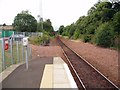
7
The line to Glasgow
On East Kilbride station platform.
Image: © Gordon Brown
Taken: 11 Feb 2008
0.20 miles
8
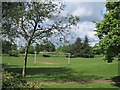
Kirktonholme Park
A playing field near East Kilbride railway station.
Image: © Richard Webb
Taken: 4 Jun 2012
0.22 miles