IMAGES TAKEN NEAR TO
Farndale, GLASGOW, G74 4QS
Introduction
This page details the photographs taken nearby to Farndale, G74 4QS by members of the Geograph project.
The Geograph project started in 2005 with the aim of publishing, organising and preserving representative images for every square kilometre of Great Britain, Ireland and the Isle of Man.

There are currently over 7.5m images from over14,400 individuals and you can help contribute to the project by visiting https://www.geograph.org.uk
Image Map
Images are licensed for reuse under creativecommons.org/licenses/by-sa/2.0
Notes
- Clicking on the map will re-center to the selected point.
- The higher the marker number, the further away the image location is from the centre of the postcode.
Image Listing (5 Images Found)
Images are licensed for reuse under creativecommons.org/licenses/by-sa/2.0
Image
Details
Distance
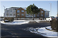
1

Hunters Bar, Stewartfield Crescent
In East Kilbride.
Image: © Stephen Sweeney
Taken: 26 Jan 2010
0.17 miles
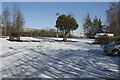
2
The view from the Kittoch
Looking across the Kittoch car park towards what I assume to be a block of flats.
Image: © Malcolm Neal
Taken: 2 Feb 2019
0.19 miles
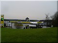
3
The Kittoch car park
The Kittoch, I think, is a cafe and has quite a sizeable car park, most of which is empty and under snow.
Image: © Malcolm Neal
Taken: 2 Feb 2019
0.20 miles

5
Morrisons petrol station, Stewartfield
Showing the rising cost of fuel.
Image: © Stephen Sweeney
Taken: 26 Jan 2010
0.25 miles