IMAGES TAKEN NEAR TO
Nerston Road, GLASGOW, G74 4NX
Introduction
This page details the photographs taken nearby to Nerston Road, G74 4NX by members of the Geograph project.
The Geograph project started in 2005 with the aim of publishing, organising and preserving representative images for every square kilometre of Great Britain, Ireland and the Isle of Man.

There are currently over 7.5m images from over14,400 individuals and you can help contribute to the project by visiting https://www.geograph.org.uk
Image Map
Images are licensed for reuse under creativecommons.org/licenses/by-sa/2.0
Notes
- Clicking on the map will re-center to the selected point.
- The higher the marker number, the further away the image location is from the centre of the postcode.
Image Listing (9 Images Found)
Images are licensed for reuse under creativecommons.org/licenses/by-sa/2.0
Image
Details
Distance
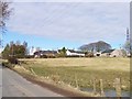
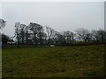
2
House at East Rogerton
Old farm house north of East Kilbride.
Image: © Stephen Sweeney
Taken: 26 Jan 2010
0.01 miles
3
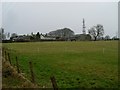
Farmland east of Rogerton
Seen from Markethill Road.
Image: © Stephen Sweeney
Taken: 26 Jan 2010
0.08 miles
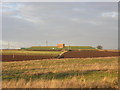
5
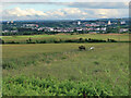
View from Nerston Road, East Kilbride
Looking towards some farm fields and a golf course, which is part of a sports complex, and East Kilbride town.
Image: © wrobison
Taken: 5 Jul 2023
0.21 miles
6
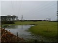
Flooding by Cairnmuir Road
Near the electricity substation north of Rogerton.
Image: © Stephen Sweeney
Taken: 26 Jan 2010
0.23 miles
7
Nerston Road beside East Rogerton reservoir
Nerston Road is one of the minor roads that lies in grassland just north of East Kilbride.
Image: © Alec MacKinnon
Taken: 10 Sep 2020
0.23 miles
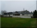
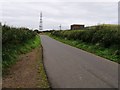
8
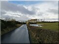
Minor road north of East Kilbride
The road passes through farmland just beyond the northern edge of East Kilbride.
Image: © Alec MacKinnon
Taken: 12 Mar 2021
0.24 miles