IMAGES TAKEN NEAR TO
East Kilbride, GLASGOW, G74 4NR
Introduction
This page details the photographs taken nearby to G74 4NR by members of the Geograph project.
The Geograph project started in 2005 with the aim of publishing, organising and preserving representative images for every square kilometre of Great Britain, Ireland and the Isle of Man.

There are currently over 7.5m images from over14,400 individuals and you can help contribute to the project by visiting https://www.geograph.org.uk
Image Map
Images are licensed for reuse under creativecommons.org/licenses/by-sa/2.0
Notes
- Clicking on the map will re-center to the selected point.
- The higher the marker number, the further away the image location is from the centre of the postcode.
Image Listing (51 Images Found)
Images are licensed for reuse under creativecommons.org/licenses/by-sa/2.0
Image
Details
Distance
1
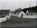
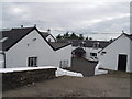
Laigh Mains
Farm off Markethill Road, north of East Kilbride.
Image: © Stephen Sweeney
Taken: 26 Jan 2010
0.03 miles
2
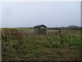
Small hut on Law Knowe
Roughly opposite Laigh Mains.
Image: © Stephen Sweeney
Taken: 26 Jan 2010
0.08 miles
3
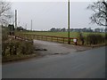
Road to High Mains Farm
From Markethill Road.
Image: © Stephen Sweeney
Taken: 26 Jan 2010
0.10 miles
4
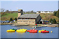
Activity Centre, James Hamilton Memorial Park
Home of many watersports activities, including canoeing and windsurfing.
Image: © Stephen Sweeney
Taken: 26 Jan 2010
0.10 miles
7
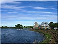
East Kilbride Heritage Park
A view of the pond and pleasure craft.
Image: © John McLeish
Taken: 18 Mar 2007
0.12 miles
8
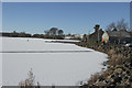
Frozen Lake
The lake at James Hamilton Heritage Park is almost completely frozen.
Image: © Malcolm Neal
Taken: 2 Feb 2019
0.12 miles

10
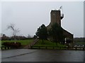
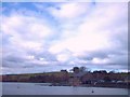
Hamiltons Farm
The farm overlooks the new heritage park on the outskirts of East Kilbride.
Image: © G McK
Taken: 9 Jul 2005
0.12 miles