IMAGES TAKEN NEAR TO
Shackleton Drive, GLASGOW, G74 4FU
Introduction
This page details the photographs taken nearby to Shackleton Drive, G74 4FU by members of the Geograph project.
The Geograph project started in 2005 with the aim of publishing, organising and preserving representative images for every square kilometre of Great Britain, Ireland and the Isle of Man.

There are currently over 7.5m images from over14,400 individuals and you can help contribute to the project by visiting https://www.geograph.org.uk
Image Map
Images are licensed for reuse under creativecommons.org/licenses/by-sa/2.0
Notes
- Clicking on the map will re-center to the selected point.
- The higher the marker number, the further away the image location is from the centre of the postcode.
Image Listing (3 Images Found)
Images are licensed for reuse under creativecommons.org/licenses/by-sa/2.0
Image
Details
Distance
1

East Kilbride Cemetery
The cemetery dates from around 1910 and is still in use.
Image: © wrobison
Taken: 9 May 2023
0.10 miles
2
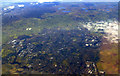
East Kilbride from the air
Viewed shortly after take-off from Glasgow.
Image: © Thomas Nugent
Taken: 6 Feb 2012
0.10 miles
3
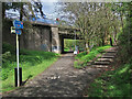
National Cycle Route 756 in East Kilbride
The route runs for 8 miles from Kelvindale in Glasgow to East Kilbride railway station. Here it follows the course of the old East Kilbride to Hamilton railway under East Mains Road. The line to Hamilton was closed in 1935 but this section remained open till 1966 to connect to the nearby Mavor and Coulson Mining Equipment works.
Image: © wrobison
Taken: 9 May 2023
0.14 miles