IMAGES TAKEN NEAR TO
Malloch Place, GLASGOW, G74 3TR
Introduction
This page details the photographs taken nearby to Malloch Place, G74 3TR by members of the Geograph project.
The Geograph project started in 2005 with the aim of publishing, organising and preserving representative images for every square kilometre of Great Britain, Ireland and the Isle of Man.

There are currently over 7.5m images from over14,400 individuals and you can help contribute to the project by visiting https://www.geograph.org.uk
Image Map
Images are licensed for reuse under creativecommons.org/licenses/by-sa/2.0
Notes
- Clicking on the map will re-center to the selected point.
- The higher the marker number, the further away the image location is from the centre of the postcode.
Image Listing (6 Images Found)
Images are licensed for reuse under creativecommons.org/licenses/by-sa/2.0
Image
Details
Distance
1

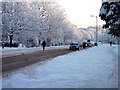
Snow
Making their way home on Calderwood Road, East Kilbride
Image: © John Steven
Taken: 6 Dec 2010
0.05 miles
2

John Wright Sports Centre
Opened in 1972, the John Wright Sports Centre is a very popular venue on Calderwood Road near the junction with St. Leonards Road.
Image: © G Laird
Taken: 11 Sep 2012
0.08 miles
3

Entering Maxwellton
Following Carlyle Drive into the conservation area in Calderwood.
Image: © Stephen Sweeney
Taken: 17 Jan 2011
0.23 miles
4

Woodland strip in East Kilbride
The strip is not used as a path as is common in other new towns.
Image: © Richard Webb
Taken: 4 Jun 2012
0.23 miles
5

Maxwellton Conservation Area, East Kilbride
Image: © Iain Thompson
Taken: 1 Oct 2005
0.24 miles
6
Walking to work
Walking to work on a snow covered St Leonards Road, East Kilbride
Image: © John Steven
Taken: 7 Dec 2010
0.25 miles