IMAGES TAKEN NEAR TO
Canongate, GLASGOW, G74 3NX
Introduction
This page details the photographs taken nearby to Canongate, G74 3NX by members of the Geograph project.
The Geograph project started in 2005 with the aim of publishing, organising and preserving representative images for every square kilometre of Great Britain, Ireland and the Isle of Man.

There are currently over 7.5m images from over14,400 individuals and you can help contribute to the project by visiting https://www.geograph.org.uk
Image Map
Images are licensed for reuse under creativecommons.org/licenses/by-sa/2.0
Notes
- Clicking on the map will re-center to the selected point.
- The higher the marker number, the further away the image location is from the centre of the postcode.
Image Listing (2 Images Found)
Images are licensed for reuse under creativecommons.org/licenses/by-sa/2.0
Image
Details
Distance
1
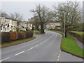
Maxwellton Road, East Kilbride
The main road through the Calderwood area of East Kilbride. Further along the road becomes St. Leonards Road.
Image: © G Laird
Taken: 27 Dec 2012
0.19 miles
2
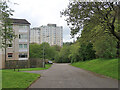
Barrie Road, East Kilbride
A 4 storey block of flats on the left and looking towards the 15 storey tower blocks.
Image: © wrobison
Taken: 9 May 2023
0.20 miles