IMAGES TAKEN NEAR TO
Stobo, GLASGOW, G74 3HJ
Introduction
This page details the photographs taken nearby to Stobo, G74 3HJ by members of the Geograph project.
The Geograph project started in 2005 with the aim of publishing, organising and preserving representative images for every square kilometre of Great Britain, Ireland and the Isle of Man.

There are currently over 7.5m images from over14,400 individuals and you can help contribute to the project by visiting https://www.geograph.org.uk
Image Map
Images are licensed for reuse under creativecommons.org/licenses/by-sa/2.0
Notes
- Clicking on the map will re-center to the selected point.
- The higher the marker number, the further away the image location is from the centre of the postcode.
Image Listing (6 Images Found)
Images are licensed for reuse under creativecommons.org/licenses/by-sa/2.0
Image
Details
Distance
1
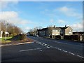
Maxwellton Road, Calderwood
Main road through the residential Calderwood in East Kilbride.
Image: © Stephen Sweeney
Taken: 17 Jan 2011
0.17 miles
2
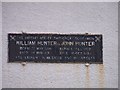
Plaque on Hunter House Museum, East Kilbride
Image: © Elliott Simpson
Taken: 5 Aug 2011
0.20 miles
3
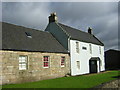
Hunter House Museum, East Kilbride
Birthplace of William Hunter (23 May 1718) and John Hunter (13 Feb 1728), pre-eminent in medicine and in surgery.
Image: © Iain Thompson
Taken: 1 Oct 2005
0.20 miles
4

Tanahill Drive
A gap in the houses in East Kilbride.
Image: © Richard Webb
Taken: 4 Jun 2012
0.20 miles
5
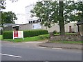
Calderwood Baptist Church, East Kilbride
Image: © Elliott Simpson
Taken: 5 Aug 2011
0.21 miles
6
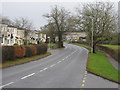
Maxwellton Road, East Kilbride
The main road through the Calderwood area of East Kilbride. Further along the road becomes St. Leonards Road.
Image: © G Laird
Taken: 27 Dec 2012
0.22 miles