IMAGES TAKEN NEAR TO
Burns Park, GLASGOW, G74 3AR
Introduction
This page details the photographs taken nearby to Burns Park, G74 3AR by members of the Geograph project.
The Geograph project started in 2005 with the aim of publishing, organising and preserving representative images for every square kilometre of Great Britain, Ireland and the Isle of Man.

There are currently over 7.5m images from over14,400 individuals and you can help contribute to the project by visiting https://www.geograph.org.uk
Image Map
Images are licensed for reuse under creativecommons.org/licenses/by-sa/2.0
Notes
- Clicking on the map will re-center to the selected point.
- The higher the marker number, the further away the image location is from the centre of the postcode.
Image Listing (5 Images Found)
Images are licensed for reuse under creativecommons.org/licenses/by-sa/2.0
Image
Details
Distance
1
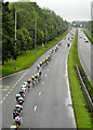
Kingsway, East Kilbride
The peloton in the Tour of Britain cycle race heads up the Kingsway, East Kilbride
Image: © Iain Thompson
Taken: 13 Sep 2008
0.08 miles
2

Maxwellton Conservation Area, East Kilbride
Image: © Iain Thompson
Taken: 1 Oct 2005
0.17 miles
3

Entering Maxwellton
Following Carlyle Drive into the conservation area in Calderwood.
Image: © Stephen Sweeney
Taken: 17 Jan 2011
0.17 miles
4

East Kilbride from the air
The A725 East Kilbride Expressway and Calderwood can be seen.
Image: © Thomas Nugent
Taken: 1 May 2017
0.22 miles
5

Kingsway, East Kilbride
The Tour of Britain cycle race heads south on the Kingsway
Image: © Iain Thompson
Taken: 13 Sep 2008
0.25 miles