IMAGES TAKEN NEAR TO
Glen Gairn, GLASGOW, G74 2JG
Introduction
This page details the photographs taken nearby to Glen Gairn, G74 2JG by members of the Geograph project.
The Geograph project started in 2005 with the aim of publishing, organising and preserving representative images for every square kilometre of Great Britain, Ireland and the Isle of Man.

There are currently over 7.5m images from over14,400 individuals and you can help contribute to the project by visiting https://www.geograph.org.uk
Image Map
Images are licensed for reuse under creativecommons.org/licenses/by-sa/2.0
Notes
- Clicking on the map will re-center to the selected point.
- The higher the marker number, the further away the image location is from the centre of the postcode.
Image Listing (5 Images Found)
Images are licensed for reuse under creativecommons.org/licenses/by-sa/2.0
Image
Details
Distance
1
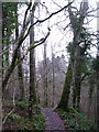
Four Oaks
A stretch of the path beside the Rotten Calder known as Four Oaks.
Image: © G Laird
Taken: 27 Dec 2012
0.14 miles
2
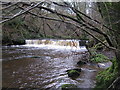
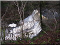
Waterfall on the Rotten Calder
One of a number of waterfalls on the Rotten Calder, this one appears to be unnamed.
Image: © G Laird
Taken: 27 Dec 2012
0.17 miles
3
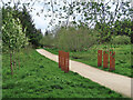
Glen Esk Urban Greenspace, East Kilbride
Located in a former landfill site and funded via the Scottish Government Vacant Derelict Land Fund. The site includes footpaths, artworks, an outdoor classroom and a junior bike track. See,
https://www.covanburn.com/covanburn-projects/glen-esk-urban-greenspace/
Image: © wrobison
Taken: 9 May 2023
0.18 miles
4
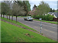
St Leonards Road, East Kilbride
One of the original parts of the new town where pedestrians are kept separate from the main roads.
Image: © wrobison
Taken: 9 May 2023
0.19 miles
5
Castle Falls
Named after the former Calderwood Castle, these falls are very impressive but hard to see when the trees are in full leaf. It is worth saving this walk to the falls until winter when you can get this good view of them.
Image: © G Laird
Taken: 27 Dec 2012
0.21 miles