IMAGES TAKEN NEAR TO
West Mains Road, GLASGOW, G74 1PT
Introduction
This page details the photographs taken nearby to West Mains Road, G74 1PT by members of the Geograph project.
The Geograph project started in 2005 with the aim of publishing, organising and preserving representative images for every square kilometre of Great Britain, Ireland and the Isle of Man.

There are currently over 7.5m images from over14,400 individuals and you can help contribute to the project by visiting https://www.geograph.org.uk
Image Map
Images are licensed for reuse under creativecommons.org/licenses/by-sa/2.0
Notes
- Clicking on the map will re-center to the selected point.
- The higher the marker number, the further away the image location is from the centre of the postcode.
Image Listing (7 Images Found)
Images are licensed for reuse under creativecommons.org/licenses/by-sa/2.0
Image
Details
Distance

2
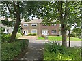
Lindores Drive
Residential area north of the A726. I was looking for the footbridge at this time.
Image: © Richard Webb
Taken: 1 Aug 2014
0.20 miles
3

Railway line between Hairmyres and East Kilbride Stations
Image: © Dannie Calder
Taken: 7 Dec 2010
0.20 miles
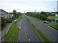
5
A726
The main road through East Kilbride and home to many a queue featuring in the traffic reports. View from an all too rare footbridge.
Image: © Richard Webb
Taken: 1 Aug 2014
0.24 miles
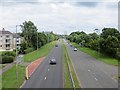
6
Autumn Colours on Queensway
Autumn colours on the Queensway, East Kilbride. Viewed from pedestrian bridge across the road.
Image: © Iain Thompson
Taken: 31 Oct 2008
0.24 miles
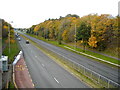
7
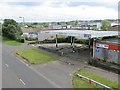
Closed garage, East Kilbride
Seen from a bridge taking a path over the A726.
Image: © Richard Webb
Taken: 1 Aug 2014
0.25 miles