IMAGES TAKEN NEAR TO
Rutherglen, GLASGOW, G73 5RG
Introduction
This page details the photographs taken nearby to G73 5RG by members of the Geograph project.
The Geograph project started in 2005 with the aim of publishing, organising and preserving representative images for every square kilometre of Great Britain, Ireland and the Isle of Man.

There are currently over 7.5m images from over14,400 individuals and you can help contribute to the project by visiting https://www.geograph.org.uk
Image Map
Images are licensed for reuse under creativecommons.org/licenses/by-sa/2.0
Notes
- Clicking on the map will re-center to the selected point.
- The higher the marker number, the further away the image location is from the centre of the postcode.
Image Listing (6 Images Found)
Images are licensed for reuse under creativecommons.org/licenses/by-sa/2.0
Image
Details
Distance
1
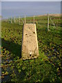
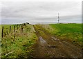
Pillar no longer marking high point
This trig point used to mark a summit of significant prominence but now there is artificially higher ground on the other side of the fence pictured thanks to Glasgow Council's South Cathkin landfill facility.
Image: © Mark Nightingale
Taken: 3 Dec 2009
0.18 miles
2
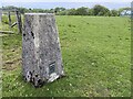
Hill Field Trig Point Flush Bracket S3609
Not shown on OS maps
Image: © thejackrustles
Taken: 15 May 2022
0.18 miles
4
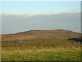
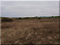
Cathkin Landfill Site
It is more hill building than land fill. The trig point on the OS map is probably well and truly buried by now.
Image: © Iain Thompson
Taken: 27 Dec 2005
0.22 miles
6
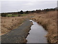
Cathkin Marsh reserve
The path and boardwalk (Image) combine to circle this boggy marsh, a haven for all sorts of interesting wildlife.
Image: © Alec MacKinnon
Taken: 14 Mar 2015
0.25 miles