IMAGES TAKEN NEAR TO
Ardbeg Avenue, GLASGOW, G73 5NF
Introduction
This page details the photographs taken nearby to Ardbeg Avenue, G73 5NF by members of the Geograph project.
The Geograph project started in 2005 with the aim of publishing, organising and preserving representative images for every square kilometre of Great Britain, Ireland and the Isle of Man.

There are currently over 7.5m images from over14,400 individuals and you can help contribute to the project by visiting https://www.geograph.org.uk
Image Map
Images are licensed for reuse under creativecommons.org/licenses/by-sa/2.0
Notes
- Clicking on the map will re-center to the selected point.
- The higher the marker number, the further away the image location is from the centre of the postcode.
Image Listing (6 Images Found)
Images are licensed for reuse under creativecommons.org/licenses/by-sa/2.0
Image
Details
Distance
1
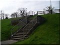
Steps leading up to East Kilbride Road
From the pedestrian walkway beside it.
Image: © Stephen Sweeney
Taken: 1 Apr 2009
0.08 miles
2
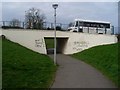
Pedestrian underpass at Langlea Road
Covered with graffiti.
Image: © Stephen Sweeney
Taken: 1 Apr 2009
0.10 miles
3
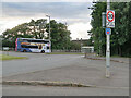
Cathkin roundabout on the East Kilbride Road
Showing a Glasgow bound No18 bus en route from East Kilbride, Greenhills. The roundabout is also on the Nation Cycle Route 756.
Image: © wrobison
Taken: 5 Jul 2023
0.17 miles
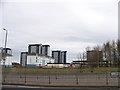
5
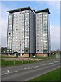
Bute Tower
One of several recently developed high flats in this area.
Image: © Stephen Sweeney
Taken: 1 Apr 2009
0.23 miles
6
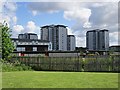
West Greenlees
High rise housing in Cammbuslang. Bet the views are good on the north facing flats.
Image: © Richard Webb
Taken: 4 Jun 2012
0.24 miles