IMAGES TAKEN NEAR TO
Brownside Road, GLASGOW, G73 5BG
Introduction
This page details the photographs taken nearby to Brownside Road, G73 5BG by members of the Geograph project.
The Geograph project started in 2005 with the aim of publishing, organising and preserving representative images for every square kilometre of Great Britain, Ireland and the Isle of Man.

There are currently over 7.5m images from over14,400 individuals and you can help contribute to the project by visiting https://www.geograph.org.uk
Image Map
Images are licensed for reuse under creativecommons.org/licenses/by-sa/2.0
Notes
- Clicking on the map will re-center to the selected point.
- The higher the marker number, the further away the image location is from the centre of the postcode.
Image Listing (18 Images Found)
Images are licensed for reuse under creativecommons.org/licenses/by-sa/2.0
Image
Details
Distance
1
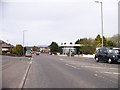
Fishescoates Service Station on the A749
Image: © Elliott Simpson
Taken: 2 May 2013
0.08 miles
2
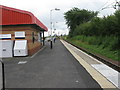
Burnside railway station, looking East
View from platform 1 at Burnside railway station, looking roughly East towards Newton.
Image: © Andrew Reid
Taken: 21 Aug 2011
0.10 miles
3
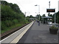
Burnside railway station, looking West
View from platform 1 at Burnside railway station, looking roughly West towards Glasgow Central.
Image: © Andrew Reid
Taken: 21 Aug 2011
0.10 miles
4
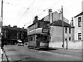
A 'Dalmarnock Bogie' car at Burnside
There were not many of these cars, which is just as well, as they were not popular with the crews and were subject to numerous minor faults. Here car 1106 is seen approaching Burnside terminus after a long run on Route 26 from Scotstoun.
Image: © Dr Neil Clifton
Taken: 11 Apr 1960
0.10 miles
5
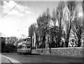
Burnside terminus
Round-dash Standard No 532 waits to return across the City to Springburn on Route 18
Image: © Dr Neil Clifton
Taken: 11 Apr 1960
0.10 miles
6
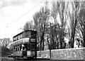
A 'Coronation' car at Burnside
In 1960, some parts of the Burnside tram route had not been completely built up. Here car No 1171 approaches the terminus along an attractive stretch of road.
Image: © Dr Neil Clifton
Taken: 11 Apr 1960
0.10 miles
7
Springfield Park Road
The entrance to Tesco's car park is on the right.
Image: © Richard Sutcliffe
Taken: 16 Jun 2018
0.17 miles
8
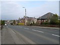
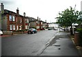
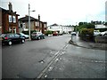
Blairbeth Road
Heading west towards High Crosshill.
Image: © Stephen Sweeney
Taken: 1 Apr 2009
0.18 miles
9
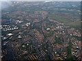
Cambuslang from the air
The River Clyde can be seen on the left.
Image: © Thomas Nugent
Taken: 3 Jun 2015
0.19 miles