IMAGES TAKEN NEAR TO
Dukes Road, GLASGOW, G73 5AD
Introduction
This page details the photographs taken nearby to Dukes Road, G73 5AD by members of the Geograph project.
The Geograph project started in 2005 with the aim of publishing, organising and preserving representative images for every square kilometre of Great Britain, Ireland and the Isle of Man.

There are currently over 7.5m images from over14,400 individuals and you can help contribute to the project by visiting https://www.geograph.org.uk
Image Map
Images are licensed for reuse under creativecommons.org/licenses/by-sa/2.0
Notes
- Clicking on the map will re-center to the selected point.
- The higher the marker number, the further away the image location is from the centre of the postcode.
Image Listing (21 Images Found)
Images are licensed for reuse under creativecommons.org/licenses/by-sa/2.0
Image
Details
Distance
1
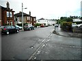
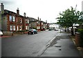
Springfield Park Road
The entrance to Tesco's car park is on the right.
Image: © Richard Sutcliffe
Taken: 16 Jun 2018
0.07 miles
2
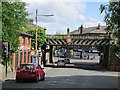
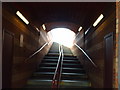
Burnside Station
Access to the station is by stairs in the bridge at the head of Stonelaw road.
Image: © Richard Webb
Taken: 4 Jun 2012
0.09 miles
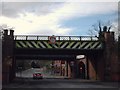
4
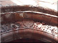
Carvings Above Burnside Station Entrance
Image: © Lynn M Reid
Taken: 25 Mar 2008
0.10 miles
6
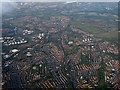
Cambuslang from the air
The River Clyde can be seen on the left.
Image: © Thomas Nugent
Taken: 3 Jun 2015
0.12 miles
8
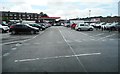
Tesco's car park
The tenements in the distance are on Stonelaw Road.
Image: © Richard Sutcliffe
Taken: 16 Jun 2018
0.13 miles
9
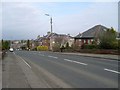
Blairbeth Road
Heading west towards High Crosshill.
Image: © Stephen Sweeney
Taken: 1 Apr 2009
0.13 miles
10
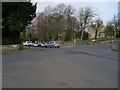
Junction of Burnside Road and Blairbeth Road
Between the areas of Burnside and High Crosshill.
Image: © Stephen Sweeney
Taken: 1 Apr 2009
0.13 miles