IMAGES TAKEN NEAR TO
Blairbeth Mews, GLASGOW, G73 4NZ
Introduction
This page details the photographs taken nearby to Blairbeth Mews, G73 4NZ by members of the Geograph project.
The Geograph project started in 2005 with the aim of publishing, organising and preserving representative images for every square kilometre of Great Britain, Ireland and the Isle of Man.

There are currently over 7.5m images from over14,400 individuals and you can help contribute to the project by visiting https://www.geograph.org.uk
Image Map
Images are licensed for reuse under creativecommons.org/licenses/by-sa/2.0
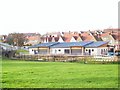
Notes
- Clicking on the map will re-center to the selected point.
- The higher the marker number, the further away the image location is from the centre of the postcode.
Image Listing (15 Images Found)
Images are licensed for reuse under creativecommons.org/licenses/by-sa/2.0
Image
Details
Distance
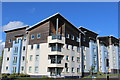
2
Spittal Estate
View of new units below Spittal Estate, looking from the junction at Blairbeth Road.
Image: © Roger May
Taken: 15 Dec 2005
0.05 miles
3
Road signs at end of Blairbeth Road
For Glasgow, Rutherglen and Castlemilk.
Image: © Stephen Sweeney
Taken: 1 Apr 2009
0.06 miles
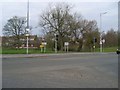
4
Dual Carriageway ahead
Road sign at the beginning of Mill Street.
Image: © Stephen Sweeney
Taken: 1 Apr 2009
0.06 miles
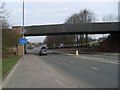
5
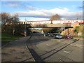
Railway Bridge in Burnside
The bridge carries the railway between Croftfoot and Burnside Railway Stations across Mill Street (A730).
Image: © G Laird
Taken: 27 Nov 2012
0.06 miles
6
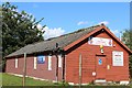
The Lighthouse Church Centre, Rutherglen
Rutherglen Pentecostal Church of God
Image: © Leslie Barrie
Taken: 9 Aug 2014
0.09 miles
7
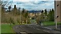
What the boy sees
View looking downhill (North) the towards Rutherglen and Glasgow from the location of the Kenny Hunter statue
Image: © Graham Crowe
Taken: 8 Apr 2014
0.12 miles
8
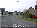
Drumilaw Road
Leads to a residential estate.
Image: © Stephen Sweeney
Taken: 1 Apr 2009
0.12 miles
9
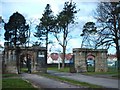
Former Gateway to Castlemilk Estate
This is now the entrance to a residential project run by the Talbot Association.
Image: © Lynn M Reid
Taken: 25 Mar 2008
0.12 miles
10
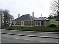
Funeral directors at Rutherglen cemetery
Image: © Stephen Sweeney
Taken: 1 Apr 2009
0.13 miles