IMAGES TAKEN NEAR TO
Neilvaig Drive, GLASGOW, G73 4HQ
Introduction
This page details the photographs taken nearby to Neilvaig Drive, G73 4HQ by members of the Geograph project.
The Geograph project started in 2005 with the aim of publishing, organising and preserving representative images for every square kilometre of Great Britain, Ireland and the Isle of Man.

There are currently over 7.5m images from over14,400 individuals and you can help contribute to the project by visiting https://www.geograph.org.uk
Image Map
Images are licensed for reuse under creativecommons.org/licenses/by-sa/2.0
Notes
- Clicking on the map will re-center to the selected point.
- The higher the marker number, the further away the image location is from the centre of the postcode.
Image Listing (6 Images Found)
Images are licensed for reuse under creativecommons.org/licenses/by-sa/2.0
Image
Details
Distance
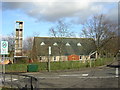
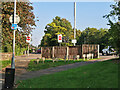
2
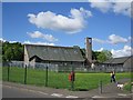
Church, Burnside
No not a practice tower for fire fighters.
Image: © Richard Webb
Taken: 4 Jun 2012
0.09 miles
3
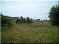
Fernhill from footpath
Looking southwest towards lower Fernhill from the parkland footpath
Image: © Graham Crowe
Taken: 8 Jul 2005
0.10 miles
4
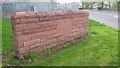
Fernhill welcome wall
An old style sandstone wall section, but a 21st century addition, denoting the eastern entrance to the Fernhill housing estate
Image: © Graham Crowe
Taken: 9 May 2014
0.11 miles
5
National Cycle Route 756
Approaching the Burnside Road crossing.
Image: © wrobison
Taken: 7 Sep 2024
0.11 miles
6
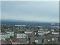
Towards Neilvaig Drive
View South over refurbished blocks in Neilvaig Drive, with High Burnside beyond and Clydebridge steel works in the distance
Image: © Graham Crowe
Taken: 2 May 2015
0.20 miles