IMAGES TAKEN NEAR TO
Mauchline Wynd, GLASGOW, G73 4BP
Introduction
This page details the photographs taken nearby to Mauchline Wynd, G73 4BP by members of the Geograph project.
The Geograph project started in 2005 with the aim of publishing, organising and preserving representative images for every square kilometre of Great Britain, Ireland and the Isle of Man.

There are currently over 7.5m images from over14,400 individuals and you can help contribute to the project by visiting https://www.geograph.org.uk
Image Map
Images are licensed for reuse under creativecommons.org/licenses/by-sa/2.0
Notes
- Clicking on the map will re-center to the selected point.
- The higher the marker number, the further away the image location is from the centre of the postcode.
Image Listing (36 Images Found)
Images are licensed for reuse under creativecommons.org/licenses/by-sa/2.0
Image
Details
Distance
1
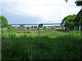
Former Spittal Sports Ground
Finally succumbed to housing development following fifteen years of dereliction and debate.
Image: © Thomas Nugent
Taken: 27 May 2017
0.02 miles
2
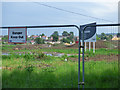
Former Spittal Sports Ground
Finally succumbed to housing development following fifteen years of dereliction and debate.
Image: © Thomas Nugent
Taken: 27 May 2017
0.02 miles
3

Lane leading to Croftfoot railway station
Off Croftend Avenue, on the south side of the station.
Image: © Thomas Nugent
Taken: 27 May 2017
0.04 miles
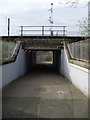
4

Croftfoot railway station
Looking into the subway from the south.
Image: © Thomas Nugent
Taken: 27 May 2017
0.05 miles
5
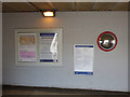
Croftfoot railway station
Information boards and a domed mirror at the foot of the stairs in the subway which serves the island platform.
Image: © Thomas Nugent
Taken: 27 May 2017
0.05 miles
6
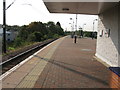
Croftfoot railway station, looking West
View from platform 1 at Croftfoot railway station, looking roughly West towards Glasgow Central.
Image: © Andrew Reid
Taken: 15 Sep 2011
0.05 miles
7

Croftfoot railway station, looking East
View from platform 1 at Croftfoot railway station, looking roughly East towards Newton.
Image: © Andrew Reid
Taken: 15 Sep 2011
0.05 miles
8
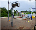
Croftfoot railway station
Facilities at the top of the stairs to the island platform including an electronic train departure & information board, smartcard scanner and a remote help point.
Image: © Thomas Nugent
Taken: 27 May 2017
0.06 miles
9
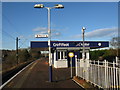
Croftfoot Railway Station
The station between Burnside and King's Park on the Cathcart Circle line.
Image: © G Laird
Taken: 27 Nov 2012
0.06 miles
10
Underpass at Croftfoot Station
Coming in off King's Park Avenue.
Image: © Stephen Sweeney
Taken: 1 Apr 2009
0.06 miles