IMAGES TAKEN NEAR TO
Broomieknowe Road, GLASGOW, G73 3QJ
Introduction
This page details the photographs taken nearby to Broomieknowe Road, G73 3QJ by members of the Geograph project.
The Geograph project started in 2005 with the aim of publishing, organising and preserving representative images for every square kilometre of Great Britain, Ireland and the Isle of Man.

There are currently over 7.5m images from over14,400 individuals and you can help contribute to the project by visiting https://www.geograph.org.uk
Image Map
Images are licensed for reuse under creativecommons.org/licenses/by-sa/2.0
Notes
- Clicking on the map will re-center to the selected point.
- The higher the marker number, the further away the image location is from the centre of the postcode.
Image Listing (15 Images Found)
Images are licensed for reuse under creativecommons.org/licenses/by-sa/2.0
Image
Details
Distance
1
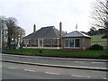
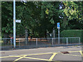
Funeral directors at Rutherglen cemetery
Image: © Stephen Sweeney
Taken: 1 Apr 2009
0.16 miles
4
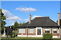
The Mill Funeral Home, Mill Street, Rutherglen
Funeral directors at Rutherglen Cemetery.
Image: © Leslie Barrie
Taken: 9 Aug 2014
0.18 miles
5
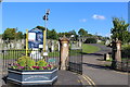
Entrance to Overtoun Park on Roger Drive
National Cycle Route 756 goes through the park.
The park was presented to the Royal Burgh of Rutherglen by Lord Overtoun following a friendly meeting with ex-Provost Rodger. For more info, see https://rutherglenheritage.wixsite.com/website-46/overtoun-park
Image: © wrobison
Taken: 7 Sep 2024
0.19 miles
6
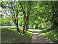
Stonelaw Woods
A park in Rutherglen with the appearance of once being a quarry.
Image: © Richard Webb
Taken: 4 Jun 2012
0.20 miles
7
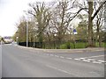
Drumilaw Road
Leads to a residential estate.
Image: © Stephen Sweeney
Taken: 1 Apr 2009
0.21 miles
8
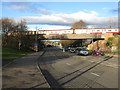
Railway Bridge in Burnside
The bridge carries the railway between Croftfoot and Burnside Railway Stations across Mill Street (A730).
Image: © G Laird
Taken: 27 Nov 2012
0.21 miles
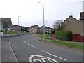
10
Junction of Stonelaw Road and Buchanan Drive
Image: © Elliott Simpson
Taken: 2 May 2013
0.22 miles