IMAGES TAKEN NEAR TO
Lauder Drive, GLASGOW, G73 3NA
Introduction
This page details the photographs taken nearby to Lauder Drive, G73 3NA by members of the Geograph project.
The Geograph project started in 2005 with the aim of publishing, organising and preserving representative images for every square kilometre of Great Britain, Ireland and the Isle of Man.

There are currently over 7.5m images from over14,400 individuals and you can help contribute to the project by visiting https://www.geograph.org.uk
Image Map
Images are licensed for reuse under creativecommons.org/licenses/by-sa/2.0
Notes
- Clicking on the map will re-center to the selected point.
- The higher the marker number, the further away the image location is from the centre of the postcode.
Image Listing (8 Images Found)
Images are licensed for reuse under creativecommons.org/licenses/by-sa/2.0
Image
Details
Distance
1
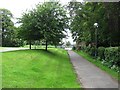
Path by Stonelaw High School
The path runs through a small park.
Image: © Richard Webb
Taken: 29 Jun 2011
0.17 miles
2
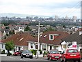
Calderwood Road
Downhill view with the high buildings of central Glasgow in the background. The 4 bedroom bungalow with the estate agent's board up is on the market for offers over £209,000.
The blue patch on the right of the picture is a gantry sign on the M74 which was opened the previous evening (28th June 2011.)
Image: © Richard Webb
Taken: 29 Jun 2011
0.19 miles
3
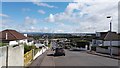
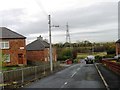
Eskdale Drive
View looking north down the steep Eskdale Drive, towards Clydebridge steel works and Cranhill/Craigend beyond
Image: © Graham Crowe
Taken: 5 Jul 2016
0.20 miles
4
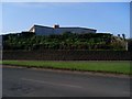
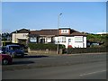
House on a hill above the Gallowflat Roundabout
In Eastfeld.
Image: © Stephen Sweeney
Taken: 1 Apr 2009
0.20 miles
7
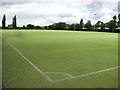
Astroturf pitch
Sports facilities behind Stonelaw High School.
Image: © Richard Webb
Taken: 29 Jun 2011
0.21 miles
8
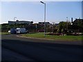
Gallowflat roundabout
On the A724 between Rutherglen and Cambuslang.
Image: © Stephen Sweeney
Taken: 1 Apr 2009
0.24 miles