IMAGES TAKEN NEAR TO
Reuther Avenue, GLASGOW, G73 2SY
Introduction
This page details the photographs taken nearby to Reuther Avenue, G73 2SY by members of the Geograph project.
The Geograph project started in 2005 with the aim of publishing, organising and preserving representative images for every square kilometre of Great Britain, Ireland and the Isle of Man.

There are currently over 7.5m images from over14,400 individuals and you can help contribute to the project by visiting https://www.geograph.org.uk
Image Map
Images are licensed for reuse under creativecommons.org/licenses/by-sa/2.0
Notes
- Clicking on the map will re-center to the selected point.
- The higher the marker number, the further away the image location is from the centre of the postcode.
Image Listing (72 Images Found)
Images are licensed for reuse under creativecommons.org/licenses/by-sa/2.0
Image
Details
Distance
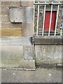
1

OS Cut Mark - Rutherglen, Greenhill Road
https://www.bench-marks.org.uk/bm135525
Image: © thejackrustles
Taken: 15 May 2022
0.03 miles
2

Location of OS Cut Mark - Rutherglen, Greenhill Road
Image: © thejackrustles
Taken: 15 May 2022
0.03 miles
4
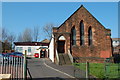
Masonic Lodge, Rutherglen
The St John's Operative Lodge Rutherglen No.347 and Lodge Toryglen No.1561, Rutherglen Glasgow.
Image: © Jim Campbell
Taken: 1 Apr 2007
0.09 miles
5

Location of OS Cut Mark - Stonelaw High School
Image: © thejackrustles
Taken: 15 May 2022
0.09 miles
6
OS Cut Mark - Stonelaw High School
https://www.bench-marks.org.uk/bm81185
Image: © thejackrustles
Taken: 15 May 2022
0.10 miles
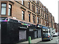
7

Gallowflat Street
A street in the centre of Rutherglen.
Image: © Richard Webb
Taken: 4 Jun 2012
0.10 miles
9
Main Street Rutherglen
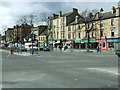
The crossroads at Stonelaw Road.
Image: © Thomas Nugent
Taken: 30 Mar 2013
0.12 miles
10
Main Street Rutherglen
The crossroads at Stonelaw Road.
Image: © Thomas Nugent
Taken: 30 Mar 2013
0.13 miles