IMAGES TAKEN NEAR TO
Bouverie Street, GLASGOW, G73 2RX
Introduction
This page details the photographs taken nearby to Bouverie Street, G73 2RX by members of the Geograph project.
The Geograph project started in 2005 with the aim of publishing, organising and preserving representative images for every square kilometre of Great Britain, Ireland and the Isle of Man.

There are currently over 7.5m images from over14,400 individuals and you can help contribute to the project by visiting https://www.geograph.org.uk
Image Map
Images are licensed for reuse under creativecommons.org/licenses/by-sa/2.0
Notes
- Clicking on the map will re-center to the selected point.
- The higher the marker number, the further away the image location is from the centre of the postcode.
Image Listing (42 Images Found)
Images are licensed for reuse under creativecommons.org/licenses/by-sa/2.0
Image
Details
Distance
1
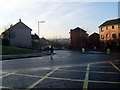
Cathcart Road
In the Burnhill area of Rutherglen.
Image: © Stephen Sweeney
Taken: 28 Jan 2009
0.07 miles
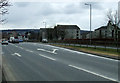
4
Looking across Glasgow Road
To the war memorial in Burnhill.
Image: © Stephen Sweeney
Taken: 28 Jan 2009
0.15 miles
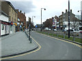
5
Glasgow Road
The traffic lights are at Main Street.
Image: © Thomas Nugent
Taken: 30 Mar 2013
0.15 miles
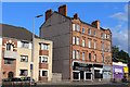
6

Chapel Street, Burnhill
In Rutherglen, just off Burnhill Street.
Image: © Stephen Sweeney
Taken: 28 Jan 2009
0.16 miles
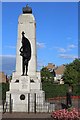
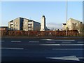
8
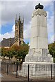
Rutherglen War Memorial
Also pictured is Rutherglen West & Wardlawhill Parish Church
Image: © Leslie Barrie
Taken: 9 Aug 2014
0.16 miles
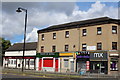
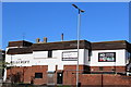
10
King Street
With Main Street in the background.
Image: © Thomas Nugent
Taken: 30 Mar 2013
0.17 miles