IMAGES TAKEN NEAR TO
Avonbank Road, GLASGOW, G73 2NZ
Introduction
This page details the photographs taken nearby to Avonbank Road, G73 2NZ by members of the Geograph project.
The Geograph project started in 2005 with the aim of publishing, organising and preserving representative images for every square kilometre of Great Britain, Ireland and the Isle of Man.

There are currently over 7.5m images from over14,400 individuals and you can help contribute to the project by visiting https://www.geograph.org.uk
Image Map
Images are licensed for reuse under creativecommons.org/licenses/by-sa/2.0
Notes
- Clicking on the map will re-center to the selected point.
- The higher the marker number, the further away the image location is from the centre of the postcode.
Image Listing (5 Images Found)
Images are licensed for reuse under creativecommons.org/licenses/by-sa/2.0
Image
Details
Distance

2
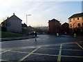
Cathcart Road
In the Burnhill area of Rutherglen.
Image: © Stephen Sweeney
Taken: 28 Jan 2009
0.19 miles
3
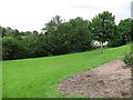
A small park off Cityford Drive
The ground although sloping was very wet.
Image: © Richard Webb
Taken: 29 Jun 2011
0.21 miles
4
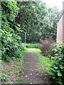
Path off Landemer Drive
A path descends past some terraced houses. There is access to a small park at the bottom on the left.
Image: © Richard Webb
Taken: 29 Jun 2011
0.22 miles
5
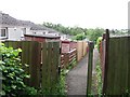
Path off Landemer Drive
A path between rows of houses off Landemer Drive.
Image: © Richard Webb
Taken: 29 Jun 2011
0.24 miles