IMAGES TAKEN NEAR TO
Bankhead Road, GLASGOW, G73 2AA
Introduction
This page details the photographs taken nearby to Bankhead Road, G73 2AA by members of the Geograph project.
The Geograph project started in 2005 with the aim of publishing, organising and preserving representative images for every square kilometre of Great Britain, Ireland and the Isle of Man.

There are currently over 7.5m images from over14,400 individuals and you can help contribute to the project by visiting https://www.geograph.org.uk
Image Map
Images are licensed for reuse under creativecommons.org/licenses/by-sa/2.0
Notes
- Clicking on the map will re-center to the selected point.
- The higher the marker number, the further away the image location is from the centre of the postcode.
Image Listing (35 Images Found)
Images are licensed for reuse under creativecommons.org/licenses/by-sa/2.0
Image
Details
Distance
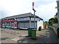
1
King's Park Avenue
Looking east at the Post Office.
Image: © Thomas Nugent
Taken: 27 May 2017
0.06 miles
2
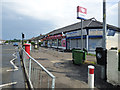
Shops on King's Park Avenue
At Croftfoot railway station.
Image: © Thomas Nugent
Taken: 27 May 2017
0.06 miles
3
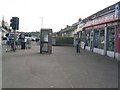
Telephone box
And King's Park Avenue Post Office.
Image: © Stephen Sweeney
Taken: 1 Apr 2009
0.07 miles
4
Shops on King's Park Avenue
At Croftfoot railway station, which is down the lane on the right.
Image: © Thomas Nugent
Taken: 27 May 2017
0.07 miles
5
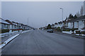
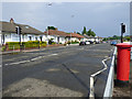
Kings Park Avenue
After the cold and snow it is raining slightly and the snow and ice are disappearing fast. Kings Park Avenue is very wide and could have four cars alongside each other, which is good because quite often there are cars parked on both sides of the road.
Image: © Malcolm Neal
Taken: 3 Feb 2019
0.08 miles
6
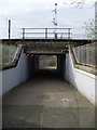
Underpass at Croftfoot Station
Coming in off King's Park Avenue.
Image: © Stephen Sweeney
Taken: 1 Apr 2009
0.09 miles
7

Croftfoot railway station
The subway, which provides public access across the line and access to the island platform. This is the north side of the subway. Surprisingly, the path is shared by pedestrians and cyclists.
Image: © Thomas Nugent
Taken: 27 May 2017
0.09 miles
8
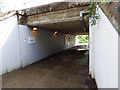
Croftfoot railway station
The subway, which provides public access across the line and access to the island platform. This is the north side of the subway.
Image: © Thomas Nugent
Taken: 27 May 2017
0.09 miles
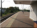
9

Croftfoot railway station, looking East
View from platform 1 at Croftfoot railway station, looking roughly East towards Newton.
Image: © Andrew Reid
Taken: 15 Sep 2011
0.10 miles
10
Croftfoot railway station, looking West
View from platform 1 at Croftfoot railway station, looking roughly West towards Glasgow Central.
Image: © Andrew Reid
Taken: 15 Sep 2011
0.10 miles