IMAGES TAKEN NEAR TO
Downiebrae Road, GLASGOW, G73 1PW
Introduction
This page details the photographs taken nearby to Downiebrae Road, G73 1PW by members of the Geograph project.
The Geograph project started in 2005 with the aim of publishing, organising and preserving representative images for every square kilometre of Great Britain, Ireland and the Isle of Man.

There are currently over 7.5m images from over14,400 individuals and you can help contribute to the project by visiting https://www.geograph.org.uk
Image Map
Images are licensed for reuse under creativecommons.org/licenses/by-sa/2.0
Notes
- Clicking on the map will re-center to the selected point.
- The higher the marker number, the further away the image location is from the centre of the postcode.
Image Listing (8 Images Found)
Images are licensed for reuse under creativecommons.org/licenses/by-sa/2.0
Image
Details
Distance

2
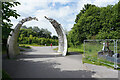
Cuningar Loop Park entrance
The arched sculpture at the entrance to the Cuningar Loop Country Park. Looking back towards the car park.
Image: © Malcolm Neal
Taken: 1 Jul 2021
0.08 miles
3
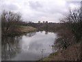
River Clyde near Dalmarnock
A secluded stretch of river
Image: © Chris Upson
Taken: 10 Mar 2006
0.13 miles
5

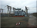
Houses on Vancouver Walk
Overlooking the River Clyde, viewed from the Clyde Walkway.
Image: © Thomas Nugent
Taken: 4 May 2019
0.15 miles
7

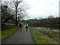
Cuningar Loop Woodland Park
The smooth path is good for wheelchair access as well as children to cycle and use their scooters.
Image: © Malcolm Neal
Taken: 1 Jul 2021
0.19 miles
8
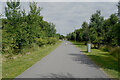
Cuningar Loop Woodland Park
The broad path is smooth and allows very young children who cannot steer their scooters properly a safe place to rush ahead.
Image: © Malcolm Neal
Taken: 1 Jul 2021
0.23 miles