IMAGES TAKEN NEAR TO
Cunningham Road, GLASGOW, G73 1PP
Introduction
This page details the photographs taken nearby to Cunningham Road, G73 1PP by members of the Geograph project.
The Geograph project started in 2005 with the aim of publishing, organising and preserving representative images for every square kilometre of Great Britain, Ireland and the Isle of Man.

There are currently over 7.5m images from over14,400 individuals and you can help contribute to the project by visiting https://www.geograph.org.uk
Image Map
Images are licensed for reuse under creativecommons.org/licenses/by-sa/2.0
Notes
- Clicking on the map will re-center to the selected point.
- The higher the marker number, the further away the image location is from the centre of the postcode.
Image Listing (11 Images Found)
Images are licensed for reuse under creativecommons.org/licenses/by-sa/2.0
Image
Details
Distance
1
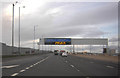
M74 Motorway bridge over Cambuslang Road (A724)
Image: © JThomas
Taken: 16 Sep 2021
0.13 miles
2
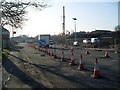
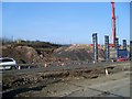
Roadworks on Cambuslang Road
At what will be one of the junctions of the M74 extension.
Image: © Stephen Sweeney
Taken: 1 Apr 2009
0.13 miles
3
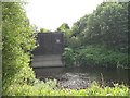
Waterside building, Clyde Industrial Estate
A utilitarian building in the River Clyde - intake, outflow, utility under the river?
Image: © Richard Webb
Taken: 25 Jul 2008
0.14 miles
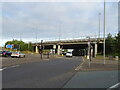
4
M74 extension
Work to connect the M74 to the M8 in Glasgow's Tradeston area.
Image: © Stephen Sweeney
Taken: 1 Apr 2009
0.16 miles
5
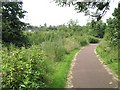
Clyde Walkway near Dalmarnock
National Cycle Route 75 and the Clyde Walkway running along a meandering section of the Clyde. A nasty infestation of Himalayan balsam (Impatiens glandulifera), a notorious invasive, beside the path.
Image: © Richard Webb
Taken: 25 Jul 2008
0.18 miles


9
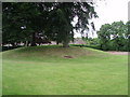
Rutherglen Main Street Tumulus
Grass-covered tumulus burial site (grave mound), believed to be Roman. Located on part of what was the garden of the former 18th century Gallowflat house (now demolished).
Image: © Paul Nardone
Taken: 12 Jun 2008
0.25 miles