IMAGES TAKEN NEAR TO
Cambuslang Road, GLASGOW, G73 1AX
Introduction
This page details the photographs taken nearby to Cambuslang Road, G73 1AX by members of the Geograph project.
The Geograph project started in 2005 with the aim of publishing, organising and preserving representative images for every square kilometre of Great Britain, Ireland and the Isle of Man.

There are currently over 7.5m images from over14,400 individuals and you can help contribute to the project by visiting https://www.geograph.org.uk
Image Map
Images are licensed for reuse under creativecommons.org/licenses/by-sa/2.0
Notes
- Clicking on the map will re-center to the selected point.
- The higher the marker number, the further away the image location is from the centre of the postcode.
Image Listing (23 Images Found)
Images are licensed for reuse under creativecommons.org/licenses/by-sa/2.0
Image
Details
Distance
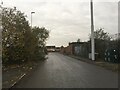
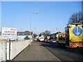
1
Duchess Road
Residential street, leading to industrial premises, in the Rutherglen area.
Image: © Stephen Sweeney
Taken: 1 Apr 2009
0.02 miles
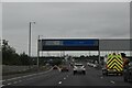
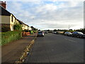
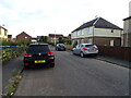
2
Cambuslang Road
Approaching Farme Cross.
Image: © Stephen Sweeney
Taken: 1 Apr 2009
0.03 miles
3
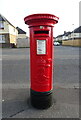
Edward VII postbox on Cambuslang Road, Rutherglen
Postbox No. G73 507.
See Image] for context.
Image: © JThomas
Taken: 16 Sep 2021
0.03 miles
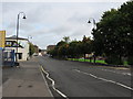
5
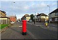
Cambuslang Road (A724), Rutherglen
Showing position of Postbox No. G73 507.
See Image] for postbox.
Image: © JThomas
Taken: 16 Sep 2021
0.04 miles
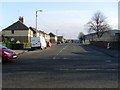
7
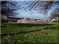
Rubble from M74 construction
Beside Cambuslang Road.
Image: © Stephen Sweeney
Taken: 1 Apr 2009
0.06 miles