IMAGES TAKEN NEAR TO
Calderglen Avenue, GLASGOW, G72 9UP
Introduction
This page details the photographs taken nearby to Calderglen Avenue, G72 9UP by members of the Geograph project.
The Geograph project started in 2005 with the aim of publishing, organising and preserving representative images for every square kilometre of Great Britain, Ireland and the Isle of Man.

There are currently over 7.5m images from over14,400 individuals and you can help contribute to the project by visiting https://www.geograph.org.uk
Image Map
Images are licensed for reuse under creativecommons.org/licenses/by-sa/2.0
Notes
- Clicking on the map will re-center to the selected point.
- The higher the marker number, the further away the image location is from the centre of the postcode.
Image Listing (6 Images Found)
Images are licensed for reuse under creativecommons.org/licenses/by-sa/2.0
Image
Details
Distance
1
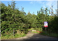
Track into woodland
Off Blantyre Farm Road (A758).
Image: © JThomas
Taken: 16 Sep 2021
0.17 miles
2
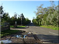
Blantyre Farm Road (A758)
Towards Blantyre.
Image: © JThomas
Taken: 16 Sep 2021
0.19 miles
3
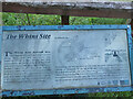
The Whins Anti Aircraft Battery
Site information board, see Image for site view.
Image: © wrobison
Taken: 4 Jun 2022
0.22 miles
4
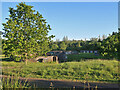
The Whins Anti Aircraft Battery
Now part of Redlees Urban Park
Image: © Jim Smillie
Taken: 9 Jun 2022
0.23 miles
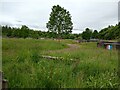
5
AA Battery in Redlees Urban Park
The Whins Anti Aircraft site dating from 1941, see Image for more info.
Image: © wrobison
Taken: 4 Jun 2022
0.24 miles
6
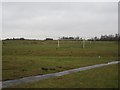
Playing field,Blantyre
A dull and damp morning on what looks like reclaimed former colliery land.
Image: © Richard Webb
Taken: 16 Mar 2013
0.24 miles