IMAGES TAKEN NEAR TO
Hunthill Road, GLASGOW, G72 9SR
Introduction
This page details the photographs taken nearby to Hunthill Road, G72 9SR by members of the Geograph project.
The Geograph project started in 2005 with the aim of publishing, organising and preserving representative images for every square kilometre of Great Britain, Ireland and the Isle of Man.

There are currently over 7.5m images from over14,400 individuals and you can help contribute to the project by visiting https://www.geograph.org.uk
Image Map
Images are licensed for reuse under creativecommons.org/licenses/by-sa/2.0
Notes
- Clicking on the map will re-center to the selected point.
- The higher the marker number, the further away the image location is from the centre of the postcode.
Image Listing (15 Images Found)
Images are licensed for reuse under creativecommons.org/licenses/by-sa/2.0
Image
Details
Distance
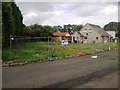
1
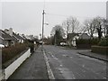
Watson Street
A residential street in Blantyre.
Image: © Richard Webb
Taken: 16 Mar 2013
0.06 miles
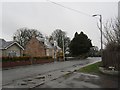
3
Stonefield Crescent, Blantyre
Just before the bend at Stonefield Place.
Image: © Stephen Sweeney
Taken: 30 Aug 2010
0.11 miles
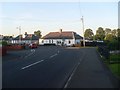
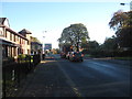
4
Looking SE on Hunthill Road
Looking towards the traffic lights at Hamilton Road/Main Street.
Image: © Stephen Sweeney
Taken: 30 Aug 2010
0.14 miles
5
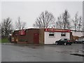
John Carrigan's
Bar, Broompark Road, Blantyre.
Image: © Richard Webb
Taken: 16 Mar 2013
0.20 miles
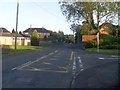
7
Heading toward the junction
Road running past Blantyre Parish Church.
Image: © James Denham
Taken: 4 Nov 2013
0.22 miles
9
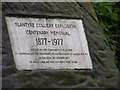
Plaque on the Centenary Memorial for the Blantyre Colliery Explosion - 1877 to 1977
Image: © Elliott Simpson
Taken: 15 Jul 2008
0.23 miles
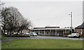
10

The Cornerstone, Main Street, High Blantyre
Image: © Leslie Barrie
Taken: 9 Aug 2014
0.23 miles