IMAGES TAKEN NEAR TO
Lime Grove, GLASGOW, G72 9JN
Introduction
This page details the photographs taken nearby to Lime Grove, G72 9JN by members of the Geograph project.
The Geograph project started in 2005 with the aim of publishing, organising and preserving representative images for every square kilometre of Great Britain, Ireland and the Isle of Man.

There are currently over 7.5m images from over14,400 individuals and you can help contribute to the project by visiting https://www.geograph.org.uk
Image Map
Images are licensed for reuse under creativecommons.org/licenses/by-sa/2.0
Notes
- Clicking on the map will re-center to the selected point.
- The higher the marker number, the further away the image location is from the centre of the postcode.
Image Listing (4 Images Found)
Images are licensed for reuse under creativecommons.org/licenses/by-sa/2.0
Image
Details
Distance
1
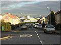
David Livingstone Memorial Primary School
David Livingstone Memorial Primary School viewed down Coatshill Avenue
Image: © Iain Thompson
Taken: 14 Jan 2006
0.08 miles
2
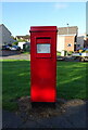
Elizabethan postbox on Blantyre Farm Road, Blantyre
Postbox No. G72 487.
See Image] for context.
Image: © JThomas
Taken: 16 Sep 2021
0.24 miles
3
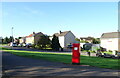
Houses on Burns Gardens, Blantyre
Showing position of Postbox No. G72 487.
See Image] for postbox.
Image: © JThomas
Taken: 16 Sep 2021
0.24 miles
4
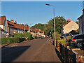
Farm Road, Blantyre
A council housing scheme built in the 50s.
Image: © wrobison
Taken: 4 Jun 2022
0.24 miles